Why does Trump want Greenland and what could it mean for Nato and the EU?
Concepts of Geographic Thinking: Spatial Significance, Interrelationships, Patterns and Trends, Geographic Perspective
Inquiry: What might be so valuable about Greenland that the US "needs"it? How might this International event impact other countries like Canada? Why might Canada and other countries and territories be concerned about US Imperialistic activities?
Activity: Collect data about what Greenland has. Gather information about how other countries view Greenland and its' resources. Create a spatial journal of the stakeholders and their views. Conduct an issue analysis to gain insight into views that different stakeholders have regarding this situation. Develop an action plan on how to deal with the conflict that is developing over Greenland. Create a story map to show a solution.

Federal government denies Marineland request to export belugas
· CBC News ·
Carney recommends 5 'nation-building projects' for approval, including LNG expansion · CBC News ·
 Concepts of Geographic Thinking: Interrelationships, Spatial Significance, Geographic Perspective
Inquiry: How might these projects impact all Canadians? How beneficial will these projects be for; people, community, Government, and the environment?
Activity: Collect data on the projects that have been approved: LNG, Nuclear Power, Port Expansion, Copper Mine, Mine Expansion. Create a spatial journal to indicate where these projects will be taking place to understand the spatial significance of the project. Conduct an issue analysis to gain perspective of the stakeholders and help develop a possible next steps for people, community, and the environment. Create a story map to communicate the next steps and the possible impacts on people, place and the environment.
Second body identified in Canada landfill amid search for serial killer’s victims

Report finds 20 per cent of newcomers leaving Canada within 25 years
The Canadian Press November 19, 2024
Inquiry: Why might Canada pay attention to this trend? How might Canada reverse this trend?
Activity: Collect data on Canadian migration. Collect data on immigrants leaving Canada. Gather information on Canadian living conditions, eduction, job opportunities, housing, and the immigrant experience. Conduct an issue analysis to gain an understanding of hy many immigrants are leaving Canada after working hard to get here. Create a spatial journal to show where immigrants are coming from and where they are going after they arrive in Canada. Build a story map to show your conclusions and express what Canada could do tpo improve the immigrant retention rate.
End of an era as Britain’s last coal-fired power plant shuts down
Inquiry: How might other G7 countries follow Britain's example and become less dependant on coal as an energy source?
Activity: Gather information about coal mining around the globe. Conduct and issue analysis to gain insight into the stakeholder involved and what they believe is important. Create a spatial journal of coal mines in Canada to help determine the interrelationships of this activity, communities, and the environment. Develop an action plan to help countries move beyond coal as an energy source and communicate it via story map.


Auditor general to probe Ford government’s Ontario Place redevelopment
By Colin D'Mello & Isaac Callan Posted November 3, 2023

Ford vows to return land to the Greenbelt. That's a 'victory' for Hamilton, says councillor
Inquiry: Where might the land developers get their projected profit of 8.2 billion dollars now that the government put the speculated land back into the untouchable Greenbelt? How might the Conservative Government pay for the reversal of their plans to develop the Ontario Greenbelt?
Activity: Collect data on the Ontario Greenbelt and the projected land that was to be developed. Create a spatial journal of the land to be developed by developers that the Ford Government has connections with. Gather data on how much the land was purchased for and how much profit these developers were going to make if they were actually allowed to build on the protected land. How might land developers make their projected profits now that they can not build there? Conduct an issue analysis and the Greenbelt timeline to help develop an action plan to understand how governments pay for projects that get cancelled. Communicate your solution via story map to ensure that that take taxpayer is not on the hook for the project profit loss by the new greenbelt land owners.

Activity: Collect data on past practices and policies of the current Government on the environment. Create a spatial journal to indicate areas in Ontario that are greatest at risk because of environmental degradation. Conduct and issue analysis to examine other groups views on environmental sustainability. Weigh the pros and cons of these views and develop an action plan that can help Ontario become more sustainable and the communicate the message via story map.
Vatican repudiates Doctrine of Discovery in response to demands from Indigenous people
· The Associated Press ·
Glaciers in the Antarctic Peninsula are Moving Faster During the Summers
Caitlin Dempsey | | Glaciology
 Concepts of Geographic Thinking:
Inquiry: How might the movement of glaciers be impacted as the Global Warming continues? How might locations prepare for what might happen as the movement of ice speeds up?
Activity: Examine the data to determine how the speed of the glaciers impacts iceberg creation. Create a spatial journal to show where glaciers are moving the fastest to determine locations that might be impacted by them. Conduct an issue analysis to understand potential stakeholders in the increase in glacier movements and iceberg creation. Create a Story Map to explain the issue and suggest how to reduce the speed of glacier movement and why this might be important for populations.
Biodiversity agreement to protect planet reached at UN conference in Montreal The Canadian Press  Concepts of Geographic Thinking: Interrelationships, Patterns and Trends, Spatial Significance, Geographic Perspective
Inquiry: What might be needed to ensure that countries meet their targets?
Activity: Conduct research into what countries have done in the past to conserve biodiversity. Complete an issue analysis to determine different views to help understand obstacles countries may need to overcome to meet their biodiversity targets. Create a spatial journal to show how spatial significance may influence different strategies to mee country targets. Develop a plan to help countries meet their goals. Communicate results via story map.
Parks Canada warns of ‘irreversible harm’ if Ontario proceeds with Greenbelt development
By
Inquiry: How might this "protected" land actually be protected? Why might protecting the Rouge National Park be important for Canadians?

Parks Canada warns of ‘irreversible harm’ if Ontario proceeds with Greenbelt development
By
Inquiry: How might this "protected" land actually be protected? Why might protecting the Rouge National Park be important for Canadians?
COP27 closes with deal on loss and damage: ‘A step towards justice’, says UN chief

12.5 per cent of Sask. population is now immigrants: 2021 census
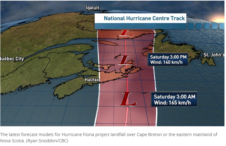
Fiona 'extremely strong and dangerous' as hurricane watch issued for P.E.I., N.S., N.L.
· CBC News ·
Concept of Geographic Thinking:Spatial Significance, Patterns and Trends
Activity: Collect data of Atlantic Maritime hurricanes. Create a graph to show how the frequency and severity have changed over time. Create a spatial journal to show parts of Canada impacted by the storms. Conduct an issue analysis to understand the different view point on how to prepare for a hurricane. Create a story map to communicate findings of inquiry.
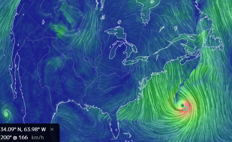
Image above from earth (https://earth.nullschool.net/)
Kwanlin Dün First Nation in
Yukon is trying to figure out
where the Chinook salmon are
Sep 06, 2022 Chinook salmon at crisis levels says First Nations in Yukon.
 Concepts of Geographic Thinking: Patterns and Trends, Interrelationships
Inquiry: Why might the Chinook Salmon in the Yukon be at their lowest levels ever? How can society insure that the species does not become extinct. What might the impacts be on the populations that rely on this resource?Activity: Gather data on the chinook stock. Examine possible human activity that might impact the fish. Conduct an issue analysis to gain further insight into the stakeholders that are apart of the issue. Create a spatial journal to show where possible impact location may be. Develop an action plan on how to address the issue and communicate the solution via story map. You may also want to create a survey123 and share with groups to create an inventory of the fish. This can be added to your spatial journal.
Pacific season’s 1st hurricane aims at Mexico tourist zone
Mon., May 30, 2022
 Concepts of Think: Spatial Significance, Patterns and Trends
Inquiry: Why might this area get hit with hurricanes? How might this hurricane seasons be different from the past ones?
Activity: Use the Geographic Inquiry Model collect and organize hurricane data. Examine weather patterns related to hurricanes. Create a spatial journal of past hurricanes to examine for patterns and make predictions on how this seasons may be different from past season. Explain why this might be happening and communicate in a story map.
Canada Opens Blockaded Bridge, but in Ottawa, Truckers Won’t Budge
Published Feb. 13, 2022, The New York Times
 Concept of Geographic Thinking: Geographic Perspective, Patterns and Trends, Interrelationships, Spatial Significance
Inquiry: Why might police in Ottawa choose not to do their job and remove the protesters like other parts of the Province? How might this action or lack of action impact a communities trust in the police institution?
Activity: Conduct an issue analysis to understand the stakeholders and their views relating the the "Trucker" protest in Ottawa. Collect evidence of law enforcement action or in action during other protest? Create a spatial journal to examine how location may play a role in how law enforcement react to protests. Create a story map to communicate the findings of the research conducted.
Published Feb. 13, 2022, The New York Times
Survey shows these Canadian cities have lost green spaces amid urbanization
By Posted February 1, 2022Inquiry: How might this pattern be reversed? What might government and industry do to ensure green space does not reduce even more?Activity: Collect data on green space in Canadian cities. Analyse data to by conducting an issue analysis to understand how and why cities depend on green space. Create a spatial journal to show the patterns and trends of this issue is happening then create a story map to describe the interrelationships required to develop solutions to this problem.
B.C. declares state of emergency in wake of devastating flooding, mudslides Bridgette Watson, Akshay Kulkarni · CBC News ·

Livable Wages in Ontario 2021 by CRAIG PICKTHORNE

B.C. forests minister introduces bill to overhaul forest practices The Canadian Press OCTOBER 20, 2021

Activity: Conduct an issue analysis to determine the stakeholders and their views on the proposed changes and outline the proposed changes. Create a spatial journal of the old growth forest in B.C. and place communities to help show the interrelationships involved in the issue. Use story map to communicate the impacts or suggestions how other primary (mining, fishing, agriculture) industries could incorporate similar strategies.
Coca-Cola, Pepsi and Nestlé named top plastic polluters for third year in a row
By Karen McVeigh, The Guardian, adapted by Newsela staff
 Concepts of Geographic Thinking: Interrelationships, Spatial Significance, Patterns and Trends
Inquiry: How might these companies be persuaded to have a more sustainable business model? Why might these companies reduction strategies not be enough to reduce garbage their packaging creates?
Activity: Conduct research on how Coca- Cola, Pepsi, and Nestle are dealing with their disposal issue. Understand how their drink products are produced. their products. Collect information on ways of reducing waste from pop drinks. Gather data on where these waste products are found. Create a spatial journal of the players involved in this issue. Conduct an issue analysis to understand the viewpoints of the different players involved in this issue. Develop a plan to communicate ways to reduce these corporations waste. Create a story map to communicate your findings.
Extensions: Use survey123 to conduct an environmental audit of your community to determine the main source of pollution. Create a spatial journal to map out the data and then create a story map to communicate your findings to encourage change in your environment.
Inside your smartphone: analyzing the rare-earth elements By
 Concepts of Geographic Thinking: Spatial Significance, Interrelationships, Geographic Perspective
After Hurricane Ida, Oil Infrastructure Springs Dozens of Leaks
By Blacki Migliozzi and
Erin O’Toole recycles a Scheer-era false claim: No, thousands of asylum seekers haven’t crossed ‘illegally’ at Roxham Road
Wed., Sept. 15, 2021
Concepts of Geographic Thinking: Geographic Perspective, Patterns and Trends, Spatial Significance
Inquiry: Why might Mr. O'Toole feel he must recycle false information? How might asylum seekers be treated better by all Canadians? How might these false views regarding asylum seekers be rectified?
Activity: Collect data on asylum seekers to Canada. Conduct an issue analysis to identify and understand stakeholders views and beliefs in this issue. Create a spatial journal using data that represents differing views across Canada. Create a story map to communicate your results to Mr. O'Toole about asylum seekers and why they are not illegal and show how improving the immigrant experience could benefited Canadians..
Climate crisis: Scientists spot warning signs of Gulf Stream collapse Damian Carrington Environment editor Thu 5 Aug 2021 16.08 BST
Concepts of Geographic Inquiry: Interrelationships, Spatial Significance, Patterns and Trends,
Inquiry: How might the Gulf Stream collapse impact coastal communities in different regions of the world? How might the Gulf Stream collapse be prevented?
Activity: Follow the path of the Gulf Stream to collect data on coastal communities that are influenced by the Gulf Stream. Record data on the pattern of climate influences in these communities. Conduct an issue analysis to determine views on ow to deal with the potential collapse of the Gulf Stream. Create a spatial journal to highlight key areas and create a story map to share possible solutions.
Global trade’s recovery from COVID-19 crisis hits record high UNCTAD 19 May 2021

Concepts of Geographic Thinking: Geographic Perspective, Patterns and Trends, Interrelationships, Spatial Significance
Inquiry: How might this rebound in Trade impact populations around the world? What might be the impact to environments as trade increase globally?
Activity: Collect data regarding Trade in 2020-2021. Collect data on environmental impacts due to increase global trade. Create a spatial journal of locations that might be impacted the most with the increase in trade. Conduct a issue analysis to gain insight to different perspectives on the issue. Create a story map to communicate the results of the investigation and promote a possible change to ensure equitable benefits.
Concepts of Geographic Thinking: Geographic Perspective, Patterns and Trends, Spatial Significance
Concepts of Geographic Inquiry: Interrelationships, Spatial Significance, Patterns and Trends,
Concepts of Geographic Thinking: Geographic Perspective, Patterns and Trends, Interrelationships, Spatial Significance
On the shores of Georgian Bay, an Ontario boom town puts a sudden stop to development. Why? It says it’s running out of water By
Inquiry: How might development impact the environment? How might other cities/municipalities develop in the face increased impact on the environment?
Activity: Conduct an issue analysis to understand the different views with this issue. Create a Spatial Journal of key places in the issue. Discuss how these areas might be impacted. Determine a course of action that would benefit the community of Collingwood. Create a Story Map to communicate your findings.

 Concepts of Thinking: Geographic Perspective, Interrelationships, Patterns and Trends, Spatial SignificanceInquiry: How might some Provinces proceed now that they are legally required to create their own carbon tax system if they do not want to follow the Federal Carbon Tax Plan? Why have some Provinces tried to make it hard for Canada to meets its Paris Accord targets by 2030?Action: Examine Canada's Paris Accord targets. Review the the strategies that Canada has committed to in achieving the targets. Conduct an issue analysis of the situation to better understand the values and beliefs of stakeholders involved in the situation. Create a spatial journal highlighting these stakeholders position. Make recommendations to the Provinces on how they should proceed to make sure the Paris Accord targets are meet by Canada and communicate this to the different levels of Government in a Story Map.
Inside a 15-year dispute between doctors and farmers over a proposed racetrack in rural Alberta. Kyle Bakx · CBC News · 
Concepts of Geographic Thinking: Spatial Significance, Geographic Perspective, Interrelationships
Inquiry: How might at risk species rebound in population if recreation developments happen in their habitat? How can a Federally protected species be at risk by a Provincial decision? How might the environment be protected if Federal and Provincial legislations do not equally value the environment?
Activity: Collect data on the Banks Sparrow in Canada to better understand how the bird is being impacted by human development. Gather data on existing raceways to determine the need for a new track. Examine data in the Federal strategy to support the Banks Sparrow. Conduct an issues analysis to fully examine the stakeholders. Create a spatial journal to identify significant areas and communicate your finds in a story map to be shared with others.
As polar vortex arrives, Canada logs coldest temperature in years.
Brooklyn Neustaeter CTVNews.ca Writer Concepts of Geographic Thinking:
Inquiry: How might the Polar Vortex influence weather across Canada?
Activity: Collect data about Canadian Polar Vortex. Conduct an issue analysis of the polar vortex to determine stakeholders views on the topic. Create a spatial journal to show the location of the polar vortex and create an action plan on how to deal with this weather phenomena and communicate via story map.
Can Wall Street help us find the true price of water?
· CBC News ·
Inquiry: How might Wall Streets commodifying of a local supply of water, which is also a human need, increase sustainable for all people?
Activity: Gather data on water supply and shortage and create a spatial journal to help show where the issue is happening. Conduct an issue analysis to better understand the stakeholders involved. Develop a position on what should happen to help reduce the Global Water Crisis and communicate via story map.

LETTER: Ontario’s conservation authorities under attack by Ford government By:

Concepts of Geographic Thinking: Spatial Significance, Geographic Perspective
Inquiry: How will the reduced function of Conservation Authorities in Ontario be impacted by this move by the Ontario Government? How will sensitive environmental areas be impacted? What can be done to protect the environmental sensitive areas under attack?
Activity: Conduct research about Bill 229 and some of the implications of the changes. Conduct an issue analysis to better understand the stakeholders involved. Create spatial journal using ArcGIS Online to identify areas at risk. Create a story map after the data has been analysed and a action plan has been created.
Concepts of Geographic Thinking: Spatial Significance, Geographic Perspective
Horseshoe crab blood is key to making a COVID-19 vaccine—but the ecosystem may suffer.
 Concepts of Geographic Thinking:
Inquiry: How might the reduction in population of the Horseshoe crab impact ecosystems? How might this change impact humans? Why are Horseshoe crabs still harvested for their blood?
Activity: Collect data regarding Horseshoe crab populations and where they are found. Conduct an issue analysis regarding the crab. Create a spatial journal to display the research. Create a Story Map to communicate what should happen regarding the the harvest of Horseshoe crabs.
State of Climate Services 2020 Report: Move from Early Warnings to Early Action.

Geographic Concepts of Thinking: Geographic Perspective, Spatial Significance, Interrelationships, Patterns and Trends
Inquiry: As the number and cost (human and dollar amount) of environmental disasters continue to increase what can be done to help all countries develop a Climate strategy that deals with Climate Change?
Task: Collect data on what countries around the world are doing to combat climate change. Gather data on what scientist suggest should be done to deal with climate change. Create a spatial journal to show how spatial significance may impact a country's plan as well as how geographic perspective influences the countries climate change agenda. Create a story map to communicate your findings
Where should lanes be closed for pedestrians and cyclists as the city comes back to life? We crunched the data
 Concepts of Geographic Thinking: Spatial Significance, Geographic Perspective, Interrelationships, Patterns and Trends
Inquiry: How might the Mayors office decide which streets would be idea to close for pedestrians.
Activity: Gather appropriate data that can be displayed in a spatial journal. Conduct an issue analysis of the data that can be used to support your decision. Create a story map to present to appropriate decision makers.
Getting started video
Students will convert xls files to csv so the data can get dropped off in ArcGIS Online.
Students will manipulate data by Classifying the data.

'No-win situation' in Wet'suwet'en protests, where police criticized for being too aggressive or too lax. Tyler Dawson February 17, 2020
 Concepts of Geographic Thinking: Geographic Perspective, Spatial Significance, Interrelationships, Patterns and Trends
Inquiry: How might the Wet'suwet'en and the Canadian Government come to a solution to the Coastal Gaslink pipeline issue?
Activity: Collect information on seeded and unseeded land to help better understand the issue. Create a spatial journal of the proposed route of the Coastal Gaslink pipeline. Conduct and Issue Analysis to better understand the stakeholders involved. Observe any patterns and trends on the Native Land interactive map to better appreciate the situation. Gather information on pipeline consideration and map out an alternative to the proposed route that might be supported by the Wet'suwet'em and the Government and communicate your results in a Story Map to the appropriate authorities.

We have 10 years to save Earth's biodiversity as mass extinction caused by humans takes hold, UN warns By Jessie Yeung, CNN
Updated 3:01 AM ET, Tue January 14, 2020
 Concepts of Geographic Thinking: Geographic Perspective, Interrelationships, Patterns and Trends, Spatial Significance
Inquiry: What might be needed to ensure that the next mass extinction does not take place?
Activity: Gather data on what factors may contribute to a species mass extinction. Understand how human activity may contribute to the 6th mass extinction. Gather data on what Governments and other stakeholders views regarding this mass extinction. Complete an issue analysis and create a spatial journal of the facts and views. Determine a plan action and communicate via story map.
Caribou 'story map' shows tale of recovery, expansion in Southern Lakes herds.
Written by John Last, based on an interview by Jane Sponagle
 Concept of Thinking: Interrelationships, Patterns and Trends, Geographic Perspective
Inquiry: How might this pattern of recovery continue? How might other species at risk be able to recover as well?
Activity: Gather data on other species that may need help recovering. Collect data on human activity that might have an impact on species in different regions of Canada. Create a spatial journal to highlight the possible interaction. Conduct an issue analysis to develop an action plan that can be communicated via story map.
Concept of Thinking: Interrelationships, Patterns and Trends, Geographic Perspective
Inquiry: How might this pattern of recovery continue? How might other species at risk be able to recover as well?
Activity: Gather data on other species that may need help recovering. Collect data on human activity that might have an impact on species in different regions of Canada. Create a spatial journal to highlight the possible interaction. Conduct an issue analysis to develop an action plan that can be communicated via story map.

New map shows which parts of Canada lag on believing in climate change.
 Concepts of Geographic Thinking:
Inquiry: Why might different parts of Canada view Climate Change differently and how might these views be changed to represent the true threat of Climate Change?
Activity: Gather information on different industries in Canada. Collect data on impacts of Climate Change by region. Conduct and issue analysis to better understand the perspectives involved. Create an action plan that connects an communicates with people the importance of acting on climate change data via story map.

Up to 800 forestry jobs lost as Teal-Jones halts harvesting in southwest B.C.Dirk Meissner · The Canadian Press ·

Activity: Gather data on the Canadian lumber. Create a Spatial Journal indicating where the lumber industry is located in Canada. Create a Story Map to outline what might happen the Canada's limber industry in the future and suggest ways to ensure its sustainability moving forward.
'We don't want to be the next cancer village': Canada's plastic recycling dumped and burned overseas Eric Szeto, Katie Pedersen, David Common and Luke Denne · CBC News ·

Do we treat our soil like dirt? The effects of soil erosion By Dennis Dimick, National Geographic, adapted by Newsela staff
 Concepts of Geographic Thinking: Interrelationships, Spatial Significance
Inquiry: How might soil erosion impact different communities?
Activity: Gather data on contributing factors that may cause soil erosion. Create a spatial journal to record where the different types of factors might be found. Evaluate some methods that may reduce soil erosion and where they may work best, add this information to the spatial journal. Develop an action plan that might be useful in a community and communicate results via story map.

Sustainable fishing
Inquiry: How might fish stocks be protected so future generations have access to this resource?
Activity: Gather data on overfishing. Conduct an issue analysis to understand of geographic perspective of the stakeholders. Review sustainable fishing practices and create a spatial journal to show where they are. Develop a plan that might work better for the Canadian fishing industry and communicate via story map.
A bold new plan to tackle climate change ignores economic orthodoxy.
The Economist
Business and financFeb 5th 2019

Inquiry: How might `going green`impact the US economy and economies of the world? Why are Canadians not wanting to "Go Green"? How might this view be changed?
Activity: Gather information on the environmental and economic impacts of "going green". Conduct an issue analysis to determine the values and beliefs of different stakeholders in going green discussion. Create a spatial journal that reflects the research of the different places that are going green. Develop a plan to help pursued other stakeholders that going green might be beneficial to them and their people and communicate via story map.

A bold new plan to tackle climate change ignores economic orthodoxy.

Inquiry: How might `going green`impact the US economy and economies of the world? Why are Canadians not wanting to "Go Green"? How might this view be changed?
Activity: Gather information on the environmental and economic impacts of "going green". Conduct an issue analysis to determine the values and beliefs of different stakeholders in going green discussion. Create a spatial journal that reflects the research of the different places that are going green. Develop a plan to help pursued other stakeholders that going green might be beneficial to them and their people and communicate via story map.
Canada's must assert sovereignty over the Arctic while there's still time
National Post, November 2, 2017
Senator Dennis Patterson: As has been the case throughout history, sovereignty often relies on the realpolitik principle of “use or lose it"

Inquiry: How might Canada maintain sovereignty of the Arctic?
Activity: Conduct research on the Laws of the Sea to determine a baseline understanding of land/sea rights. Conduct an issue analysis of the countries and communities in the region. Create a spatial journal to help develop plan of action and communicate via story map to an appropriate audience.

Oil vessel off the Newfoundland coast spills 250,000 litres of crude Malone Mullin · CBC News · Nov 16, 2018

Concepts of Thinking: Interrelationships, Geographic Perspective, Spatial Significance, Patterns and Trends
Inquiry: What might be needed to ensure these "accidents" stop happening? How will communities be impacted by future drilling plans?
Activity: Gather data on oil drilling off the coast of Newfoundland and Labrador to create a spatial journal. Collect information on the stakeholders to conduct an issue analysis. Develop an action plan to communicate a potential solution and create a story map to communicate the result.
Related stories:
All offshore oil rigs shut down in N.L. after Husky Energy spill: board

Poor weather prompts temporary shutdown of all N.L. offshore rigs
Explosion at Saint John refinery raises questions over how information was shared with public By Andrew Cromwell
Inquiry: How might this explosion impact communities?
Activity: Gather information on the oil refinery to determine the life cycle of the oil coming into the refinery. Create a spatial journal to identify some of the location Irving Oil gets it's resource from. Conduct an issue analysis and develop a strategy to help deal with future issue regarding oil transportation. Communicate results via story map.

Hamilton throws support behind Ingersoll's fight not to take Toronto's trash
· CBC News ·

Plastic fibres found in tap water around the world, study reveals Damian CarringtonEnvironment editor
 Concepts of Thinking: Interrelationships, Spatial Significance
Inquiry: How might these plastics entered the system? What might the impact be of these plastics?
Activity: Gather data on plastic fibers in water. Conduct an issue analysis to help develop a potential solution. Communicate result via story map and communicate results.

Plastic fibres found in tap water around the world, study reveals Damian CarringtonEnvironment editor

The worst age for women to have kids in terms of career
Inquiry: How might this wage discrepancy best be reduced?
Activity: Conduct research to determine the wage gap in several countries of the world and create a spatial journal. Conduct an issue analysis to help develop a plan of action. Create a story map to communicate potential solution.

Renewables grew twice as fast as fossil fuels in 2017.
 Concepts of Thinking: Interrelationships, Geographic Perspective, Patterns and Trends, Spatial Significance
Inquiry: How might this trend impact future energy development projects?
Activity: Gather data regarding renewables from a variety of sources. Create a spatial journal to determine the role spatial significance plays in the production and type of renewable utilized. Identify the stakeholders and conduct an issue analysis. From the information gathered and mapped make a suggestion on how the world should progress. Communicate via story map.

Canadian teen tells UN 'warrior up' to protect water Melissa Kent · CBC News ·

Inquiry: How might water equity be achieved?
Activity: Gather data on fresh water in Canada and the world. Conduct an issue analysis and develop a plan of action to address the problem. Create a spatial journal to represent the data. Comunicate solution via story map.

New road will be Canada's first permanent link to Arctic coast The Canadian Press Bob Weber
 Concept of Thinking: Spatial Significance, Geographic Perspective, Interrelationship
Inquiry: How might this road impact communities along its length?
Activity: Create a spatial journal of potential impact sites. Conduct an issue analysis to help make predictions as to how this new road may impact communities and at what cost. Create a story map to co

21.9% of Canadians are immigrants, the highest share in 85 years: StatsCan By Éric Grenier, CBC News
 Concepts of Thinking: Patterns and Trends, Spatial Significance,
Inquiry: Why might so many people want to come to Canada? How might this increase impact Canada?
Activity: Gather data on the spatial significance of places people are leaving. Create a spatial journal representing the data and observe for any patterns and trends. Communicate observation and possible impacts via story map.

Toronto noise levels prompt concern from city's medical officer of health By John Rieti, CBC News

Concepts of Thinking: Spatial Significance, Patterns and Trends
#Inquiry: How might the noise level impact your community?
Activity: 1) Create a spatial journal to identify the noise levels. Evaluate for hot spot to determine areas of concern. Conduct an issue analysis to develop an action plan and communicate to an appropriate audience via story map.
2) Conduct a neighbourhood audit of noise levels to determine local noise levels. Communicate results and action plan to an appropriate audience.
Toronto Islands residents bracing for lake levels to rise up to 25 cm in weeks ahead
By Lauren Pelley, CBC News
 Concepts of Thinking: Spatial Significance, Interrelationships
Inquiry: How might this water level increase impact this community and others?
Activity: create a map of the elevation, communities, and water levels. Use the issue analysis to determine different perspectives. Decide what should be done and communicate to an appropriate audience via story map.

'Anything that is recoverable, will be': Husky oil spill clean-up resumes CBC News Posted: May 08, 2017 10:38 AM CT
 Concepts of Thinking: Geographic Perspective, Interrelationships, Spatial Significance
Inquiry: How might this type of spill be best managed? How might this type of spill have been preventable now and in the future?
Activity: Map out where the oil spill has taken place as well as communities and add in physical features such as rivers and wetlands. Determine what might the impacts be. Conduct an issue analysis to help develop a strategy to clean up the mess and a strategy to prevent oil spills in the future. Communicate via story map.

Forgotten Wonders: Stunning Landscapes In Canada We Often Forget About Huffington Post April 20th, 2017
 Concepts of Thinking: Spatial Significance, Patterns and Trends, Interrelationships, Geographic Perspective
Inquiry: Why these locations have been classified "Forgotten"?
Activity: Create an annotated map and evaluate for the Geographic concepts of thinking. Determine what might be necessary to ensure that these locations maintain their "wonder" classification. Communicate to an appropriate audience via story map.

Receding glacier causes immense Canadian river to vanish in four days Hannah Devlin
 Concepts of Thinking: Patterns and Trends, Interrelations, Spatial Significance
Inquiry: How might this drastic change impact communities.
Activity: Gather landform data of river basins feed by glaciers. Create models of predicted basin change due to increased glacier melt. Conduct an issue analysis and communicate results to an appropriate audience via story map.
 Concepts of Thinking: Patterns and Trends, Interrelations, Spatial Significance
Sea Ice Extent Sinks to Record Lows at Both Poles Maria-José Viñas NASA's Earth Science News Team

Concepts of Thinking: Patterns and Trends, Spatial Significance, Interrelationships, Geographic Perspective
Inquiry: How might communities in the north and south be impacted by the loss of sea ice? How can communities prepare for this loss?
Activity: Conduct an issue analysis to determine possible action that might be required. Communicate results via story map to the appropriate authorities.

Oceans at Risk


Concepts of Thinking: Spatial Significance, Geographic Perspective
Inquiry: How might different stakeholder ensure the survival of the oceans?
Activity: Create an annotated map of active stakeholders and what they are doing. Conduct an issue analysis. Develop of plausible solution to the issue and communicate via story map.
Lethbridge urges residents to conserve water due to ice jams, quick melt The Canadian Press
 Concepts of Thinking: Interrelationship, Spatial Significance, Patterns and Trends
Inquiry: How might ice jams and quick melt be managed so as not to impact communities
Activity: Gather information on annual melt in the area and water treatment option. Decide how best to approach the situation. Communicate the results via story map.

Oil price will soar without investment in capacity, says watchdog

Concepts of Thinking: Spatial Significance, Interrelationships, Patterns and Trends, Geographic Perspective
Inquiry: How might this impact the Canadian Economy? How might this impact consumers?
Activity: Create an annotated map of oil infrastructure. Create graphs of oil prices to determine trends. Add information of global issues i.e. conflict/government policy etc. Conduct an issue analysis to help determine a possible solution and communicate via story map.
Ottawa's northern representative proposes 'Indigenous protected areas' for Arctic By Bob Weber, The Canadian Press
 Concepts of Thinking: Spatial Significance, Geographic Perspective, Interrelationships
Inquiry: How might this protection impact the north? How might Spatial Significance impact risk levels?
Activity: Collect data on northern areas at risk to determine what risks there are. Create an annotated map to show potential areas to be protected. Develop a story map to communicate results to an appropriate audience.
New map reveals the world’s most toxic countries by Lacy Cooke
 Concpets of Thinking: Patterns and Trends, Spatial Significance
Inquiry: Why do these countries have the toxic levels they do? How might countries best reduce their levels?
Activity: Gather information of toxicity. Conduct an issue analysis and determine what might be done to reduce levels. Communicate results to the appropriate audience via story map.
Ottawa's northern representative proposes 'Indigenous protected areas' for Arctic By Bob Weber, The Canadian Press

New map reveals the world’s most toxic countries by Lacy Cooke

'Excited over the simple things': First Nation enjoys turning on the taps after 10 years without clean water By Jennifer Choi, CBC News
 Concepts of Thinking: Interrelationships, Spatial Significance, Geographic Perspective, Patterns and Trends
Inquiry: How might this clean water be sustained? How might a water ban in almost 1000 communities in Canada be lifted?
Activity: Conduct an issue analysis of the water ban. Evaluate the different perspectives of the issue and develop a plan to address the problem of clean water in First Nations communities. Communicate via story map to an appropriate audience.

Canada's Glaciers Are Causing Global Sea Levels To Rise The Huffington Post Canada | By Sarah Rieger
 Concepts of Thinking: Interrelationships, Spatial Significance, Patterns and Trends
Inquiry: How might this Glacier ice melt impact communities in Canada?
Activity: Gather information on Canadian glacier melt and communities and create an annotated map. Create a graph of data and analyse to make predictions as to what might happen if this pattern continues. Create a story map to communicate to an appropriate audience.

Extraordinary' levels of pollutants found in 10km deep Mariana trench Damian Carrington
Concepts of Thinking: Interrelationships, Spatial Significance
Inquiry: Why might these toxins be of concern?
Activity: Gather information on ocean pollutants and create a spatial journal of the sources. Conduct an issue analysis to develop a possible course of action and communicate to appropriate audience via story map.

Canada Census: Western Canada's Population Booms Despite Economic Downturn | By Jennifer Graham, The Canadian Press
 Concepts of Thinking: Spatial Significance, Patterns and Trends, Geographic Perspective
Inquiry: How might this growth impact Canadian population? Economy?
Activity: Create a spatial journal of population growth in Canada's cities. Gather data on national population, economy. Create a Story Map to communicate results.

Federal funding gap disadvantages First Nations students: PBO
Concepts of Thinking: Spatial Significance, Geographic Perspective, Patterns and Trends
Inquiry: How might this gap be reduced? Why hasn't the gap be reduced already?
Activity: Gather data on Education funding for the nation and create an annotated map. Conduct an issue analysis to develop an understanding of the problem. Suggest a solution and communicate to an appropriate audience via story map.
OPEC agrees first output cut since 2008; Saudis open to ‘big hit’, but details still unclear Ahmad Ghaddar, Alex Lawler and Rania El Gamal, Reuters
 Concepts of Thinking: Geographic Perspective, Interrelationships, Spatial Significance, Patterns and Trends
Inquiry: Who might these restrictions impact Canadians? Why might OPEC countries be willing to cut oil production?
Activity: Create an annotated map of OPEC countries and countries that import oil to. Observe for patterns and trends. Conduct an issue analysis to help evaluate the consequences of this reduction. Develop a plan to account for this project cuts and communicate via story map.

Inquiry: Who might these restrictions impact Canadians? Why might OPEC countries be willing to cut oil production?
An ugly homicide number we need to discuss
Scott Gilmore November 25, 2016
 Concepts of Thinking: Interrelationships, Geographic Perspective, Patterns and Trends, Spatial Significance
Inquiry: Why might Indigenous homicide rates be so high in the far north? What might be needed to reduce these rates?
Activity: Conduct an issue analysis to determine the views that might be contributing to the problem. Create an annotated map of collected data to illustrate the problem. Develop a solution and communicate via story map to an appropriate audience.

Researchers fear B.C. coast becoming dangerous for returning whales By Liam Britten, CBC News

Concepts of Thinking: Interrelationships, Spatial Significance, Patterns and Trends
Inquiry: How has the natural movement of the whale become so dangerous? What might the best resolution to this problem be.
Activity: Create a spatial journal/annotated map of the issue. Conduct an issue analysis and incorporate geographic perspective to develop a resolution. Communicate via story map.

The State ofCircumpolar Walrus Populations, WWF Canada
Prepared by Jeff W. Higdon and D. Bruce Stewart
 Concepts of Thinking: Patterns and Trends, Interrelationships, Spatial Significance, Geographic Perspective
Inquiry: How might human activity impact walrus populations? What might be the best way to reduce human impact on the walrus?
Activity: Create a spatial journal of the area the walrus occupy and to this map data on human activity. Use a Venn diagram to help organize data for analysis. Conduct an issue analysis to come up with ways to support the walrus populations. Communicate via story map.

Canadians' Quality Of Life Not Keeping Up With Economic Growth: Study
The Huffington Post Canada | By Daniel Tencer

Concepts of Thinking: Patterns and Trends, Geographic Perspective, Spatial Significance
Inquiry: Why might people's quality of life not be keeping up with GDP growth? How might Canadians increase their quality of life?
Activity: Gather information on quality of life indicators. Conduct an issue analysis to develop a geographic perspective and suggest possible ways to improve quality of life. Communicate via story map.

Canadians Will Need 20% More Income To Buy That House They Wanted

Concepts of Thinking: Spatial Significance,
Geographic Perspective, Patterns and Trends
Inquiry: How might this increase impact the Canadian economy?
Activity: Gather data on factors that contribute to the Canadian economy. Conduct an issue analysis to determine the impacts. Decide on a path that might have least negative impact on the Canadian economy. Communicate results via story map.

Big oil v orcas: Canadians fight pipeline that threatens killer whales on the brink

Concepts of Thinking: Interrelationships, Spatial Significance, Geographic Perspective
Inquiry: What might be the best way to meet the need for oil and meet the need for conservation?
Activity: Use the concepts of thinking graphic organizers and conduct an issue analysis. Use this information to create a spatial journal to decide on how to move forward. Develop a story map to communicate to an appropriate audience.

Photo of the Day National Geographic
 Concepts of Thinking: Spatial Significance, Interrelationships, Geographic Perspective, Patterns and Trends
Inquiry: Where might these photos have been taken. Why might these photos have been taken?
Activity: Examine the photos and develop inquiry questions that might be used for each of the photos. Try to answer the questions and communicate.
Every year, nearly 1.3M people die in traffic accidents.
 Concepts of Thinking: Patterns and Trends, Spatial Significance
Inquiry: How might car fatalities be stopped globally?
Activity: Gather data to create a spatial journal of car fatalities. What might account for any patterns and trends that can be observed? Conduct an issue analysis of the issue. Communicate via story map.

Every year, nearly 1.3M people die in traffic accidents.

Oil may hit ‘low-$40s’ if OPEC fails to deliver quota deal: Goldman Sachs Ben Sharples, Bloomberg News
 Concepts of Thinking: Interrelationships, Spatial Significance, Geographic Perspective, Patterns and Trends
Inquiry: How might the change in oil prices impact Canadians?
Activity: Gather data on world oil prices and the global economy. Create a spatial journal of key events. Make predictions as to what now might happen and communicate via a story map.

Inquiry: How might the change in oil prices impact Canadians?
Italy earthquake: 6.6-magnitude tremor rocks nation's center
 Concepts of Thinking: Spatial Significance, Patterns and Trends, Interrelationships
Inquiry: How could people prepare for such an event?
Activity: Create a spatial journal of past earth quakes in the region (patterns and trends). Conduct an issue analysis to develop possibilities to help the region. Communicate via story map.

Prescribed burns begin in Kananaskis Valley By Erika Stark, CBC News
 Concepts of Thinking: Geographic Perspective, Spatial Significance, Interrelationships, Patterns and Trends
Inquiry: How might the decision where to burn be made?
Activity: Gather relevant data and create a spatial journal. Conduct an issue analysis and determine where to burn and/or what other things might be done instead of prescribed burns. Communicate results via story map.

Global Gender Pay Gap Won't Close For 170 Years: Report By The Associated Press
 Concepts of Thinking: Patterns and Trends, Spatial Significance, Geographic Perspective
Inquiry: What might be necessary to create a situation where women and men earn the salary for the same work?
Activity: Create a spatial journal of the countries and the percentage gap they hold. Observe for patterns and trends and develop a strategy that might help improve the situation for women so that they can actually earn the same. Communicate the strategy via story map.

The Migration of Anatomically Modern Humans
 Concepts of Thinking; Spatial Significance, Patterns and Trends
Inquiry:Why might people have migrated? How might people have traveled? Why did people choose their routes? How might these routes relate to current migration routes?
Activity: Gather data on current migration (An other source). Create a proportional width arrow map indicating routes and numbers. Conduct an issue analysis and develop predictions to help meet the needs of future migrants. Communicate via story map.

Arctic indigenous leaders from Alaska, Russia, and Canada to make historic London address on impacts of Arctic Ocean shipping Press release from Pacific Environment
 Concepts of Thinking: Spatial Significance, Interrelationships, Geographic Perspective
Inquiry: Why might such an address be needed? How might this address impact the region?
Activity: Conduct an issue analysis of the issue. Create a spatial journal to help understand the importance of spatial significance in the region. Evaluate the interrelationships and develop a plan that can be communicated to the appropriate audience via story map.

Diesel spill near Bella Bella an 'environmental disaster,' says nearby First Nation By Megan Thomas, CBC News
 Concepts of Thinking: Spatial Significance,
Interrelationships, Geographic Perspective
Concepts of Thinking: Spatial Significance,
Interrelationships, Geographic Perspective
Inquiry: How might this spill impact the region? What might be the best way to deal with this situation?
Activity: Create a spatial journal of this spill and the affected area. Conduct an issue analysis and develop a solution to the situation. Communicate results via story map.

Mariner's guide wants to reduce risk of shipping on Arctic wildlife. By Sima Sahar Zerehi, CBC News
 Concepts of Thinking: Geographic Perspective, Interrelationships
Inquiry: How might shipping impact local environments?
Activity: Create a route through the shipping lanes in the Arctic to reduce environmental impacts.Gather data on the arctic shipping. Create a story map to share findings/suggestions.

Retreating glacier makes Yukon sheep easy targets for hunters
 CBC News Posted: Oct 05, 2016 7:28 AM CT
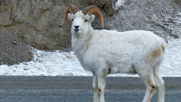
Concepts of Thinking: Spatial Significance, Interrelationships, Geographic Perspective, Patterns and Trends
Inquiry: What might happen with reduced numbers of sheep?
Activity: Gather information on the range of the glaciers and the sheep to create a spatial journal. Conduct an issue analysis and determine what the best course of action might be. Communicate via story map.
Second Harvest Turns Food Waste Into 22,000 Free Meals A Day
 Concepts of Thinking: Geographic Perspective, Patterns and Trends
Inquiry: Why might there be so much waste of food? How can people reduce their waste? What might be required to help reduce the number of people going hungry?
Activity: Conduct some research on hunger in Canada and the world. Create a spatial journal of food waste and hunger are there any patterns and trends that can be observed. Conduct an issue analysis to determine possible solutions and communicate via story map.

Expect a warmer-than-normal fall, says Environment Canada
 Concepts of Thinking: Spatial Significance, Patterns and Trends, Interrelationship, Geographic Perspective
Inquiry: What might the warmer fall impact look like? How could this weather impact different populations?
Activity: Research weather patterns in Canada. Create a spatial journal of weather from past to present. How might meteorologist be able to predict the weather How does this current weather prediction fit in? Make predictions of impacts based on the climate predictions. Communicate predictions and possible actions required via story map to an appropriate audience.

Canadian EI Claims Grew By Over 24,000 In July. Almost All Are Men

 Concepts of Thinking: Patterns and Trends, Geographic Thinking, Spatial Significance
Inquiry: How might this increase in unemployment impact local, provincial, federal economic situation?
Activity: Conduct some research on Canada's unemployment rate. Create a spatial journal to show regional rates. What might account for any difference that may be observe between the regions and over time? What might be the best way to deal with the current situation. Conduct an issue analysis to gain insight on the stakeholders. Communicate potential solutions to the appropriate audience via story map.

Are Canada’s marine protection plans at sea?
 Concepts of Thinking: Geographic Perspective, Interrelationships,
Inquiry: What might it take for Canadian marine protection policies to be more meaningful?
Activity: Research what the Canadian policies actual are. Conduct an issue analysis to help develop a decision and communicate via story map to an appropriate audience.

‘Ghost Forests’ Appear As Rising Seas Kill Trees
 By John Upton
Concepts of Thinking: Spatial Significance, Geographic Perspective, Interrelationship
Inquiry: What might the impacts be from the rising water levels impact local, provincial, national, and international populations.
Activity: Create a spatial journal of places that might be impacted the most form the rising sea level. Add human activities and conduct an issue analysis to determine impacts. Create a story map to communicate finds.

ENDANGERED SPECIES: WHY SHOULD I CARE? ·

First Nations learn to map territories using Google Earth
 Concepts of Thinking: Spatial Significance,
Inquiry: Why might First Nations want to map out their Territories? How might this new way of mapping impact their Territory?
Activity: Conduct an issue analysis of First Nations Territory to get different perspective of the issue. Create a spatial journal showing/supporting the different views. Develop a solution regarding the issue of First Nations land and communicate via story map to an appropriate audience.
Florida Has a Competition to Hunt Pythons

Florida Has a Competition to Hunt Pythons

Canadian Economy Needs 10, 15 Years To Reinvent Itself, RBC CEO Says
 Concepts of Thinking: Patterns and Trends, Geographic Perspective, Spatial Significance
Inquiry: Why might the Canadian Economy need to reinvent itself?
Activity: Conduct an issue analysis to help develop an increased understanding of the issue. Create a spatial journal of the different regions and what possible changes might be needed. Come up with strategies to facilitate reinvention ans communicate to an appropriate audience via story map.

NATIONAL PARKS PLAN FOR CLIMATE CHANGE THE WAY THE MILITARY PLANS FOR NUCLEAR WAR natgeoed.org
 At Badlands National Park, home to this bison, rangers and other leaders are developing strategies to address diverse scenarios created by climate change.
Photograph courtesy Badlands National Park, National Park Service
Concepts of Thinking: Geographic Perspective, Interrelationship, Spatial Significance
Inquiry: How might the impacts of climate change influence how National Parks prepare for the future?
Activity: Conduct research on climate change and its impacts. Create a spatial journal of the National Parks and suggests strategies that are best suited for each National Park that can be communicated to an appropriate audience.

Photograph courtesy Badlands National Park, National Park Service
Canadian, U.S., mayors oppose Great Lakes water diversion request CTV News
 Concepts of Thinking: Spatial Significance, Geographic Perspective
Inquiry: How might this diversion impact the Great Lakes ecosystem?
Activity: Conduct an issue analysis for the proposal. Create a spatial journal of the Great Lakes St. Lawrence Water Way. Create a story map to communicate whether or not the proposal should be excepted and communicate to an appropriate audience.

Hamilton will have 633K residents by 2026, says ward boundary study By Samantha Craggs, CBC News
 Concepts of Thinking: Spatial Significance, Patterns and Trends
Inquiry: How might this population growth impact the environment. What might be the best way for this population to be distributed in the area?
Activity: Create a spatial journal of population density of the Hamilton area. Evaluate the patterns and trends to make predictions to future growth. Add some environmental data and any other relevant information. Create a story map to explain the best population distribution that might impact the environment the least and communicate to the appropriate audience.

Fort McMurray, still recovering from wildfire, dealing with flooding By Mack Lamoureux, Wallis Snowdon

Concepts of Thinking: Interrelationships, Spatial Significance,
Inquiry: How might the fire have contributed to the flood? What might the new Fort McMurray be designed to better deal with these natural disasters?
Activity: Gather infrastructure information on Fort McMurray. Create a story map of the of a potential city plan that would be able to best deal with potential natural disasters such fire and flooding.

Canada Calls Out Russia For Lack Of Warning About Incoming Rocket

Concepts of Thinking: Spatial Significance, Interrelationships, Geographic Perspective
Inquiry: How can the Russian Government be accurate regarding the location of the debris re-entry? How might the Russian government respond to Canada's "Call Out" of Russia?
Activity: Create a spatial journal of the area to be impacted. Add to it human and animal information of the area. Conduct an issue analysis to develop a solution. Communicate the solution to an appropriate audience via story map.

Boil water advisory in effect for Gatineau CBC News
 Concepts of Thinking: Interrelationships, Spatial Significance, Geographic Perspectives,
Inquiry: How might the reaction to the Hull boil water advisory be different from the
Neskantaga First Nation of nearly 20 years?
Activity: Create a spatial journal of boil water advisories in Canada. Add community and infrastructure data. Conduct an issue analysis to gain regarding access to clean water. Communicate a plan to make clean water accessible to all Canadians via story map.
Map: Every Canadian hurricane landfall since 1866

Concepts of Thinking: Spatial Significance, Patterns and Trends, Interrelationships
Inquiry: Why might hurricanes be most prevalent in these areas? Why doesn't this pattern continue year round? How might human activities in the region modify their practice because of this pattern?
Activity: Create a spatial journal similar to this using data to plot. Add to it human activity, shipping, and mining data. Develop a strategies regarding how might people prepare for the next "big one". Create a story map to communicate the plan.

Neskantaga First Nation of nearly 20 years?
Map: Every Canadian hurricane landfall since 1866

Inquiry: Why might hurricanes be most prevalent in these areas? Why doesn't this pattern continue year round? How might human activities in the region modify their practice because of this pattern?
Activity: Create a spatial journal similar to this using data to plot. Add to it human activity, shipping, and mining data. Develop a strategies regarding how might people prepare for the next "big one". Create a story map to communicate the plan.
Returning Fort McMurray residents face long road to recovery By Amy Husser, CBC News
 Concepts of Thinking: Interrelationships, Patterns and Trends, Geographic Perspective
Inquiry: How might be the focus of Fort McMurray's redevelopment impact the future growth of the city?
Activity: Create a spatial journal of the resources currently supporting Fort McMurray. Add possible alternative/new resource opportunities, natural features, and human activity data. Evaluate the map to develop a plan for redevelopment that could better protect the city from being a boom bust, one resource, based city. Communicate the plan to the appropriate audience via story map.

Condemned Fort McMurray properties could remain uninhabitable until September
 Concepts of Thinking: Spatial Significance, Interrelationships, Geographic Perspective
Inquiry: How might Fort McMurray be rebuilt based on economic/social/political factors?
Activity: Develop a rebuild plan for the city. What consideration might be most important? Conduct an issue analysis. Communicate results via a story map.

Not all wood pellets are carbon-neutral, says environmental advocate By Mitch Wiles, CBC News Posted: May 25, 2016 6:00 AM CT
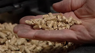 Concepts of Thinking: Geographic Perspective, Interrelationships,
Inquiry: Why are wood pellets being used instead of wood for burning? How can a carbon wood pellet be made carbon -neutral? Why might whole trees be used to create wood pellets?
Activity: Conduct an issue analysis and map out the stakeholders. How might spatial significance impact the type of wood pellet? Moving forward how should industries react to the findings that not all wood pellets are carbon-neutral? Communicate results via story map.

Rare wasp species found on New Brunswick beaches
By Kate Letterick, CBC News Posted: May 25, 2016
 Concepts of Thinking: Spatial Significance, Patterns and Trends
Inquiry: How might the environment have changed for the wasps numbers increase? What might have caused their numbers to have dropped in the first place?
Activity: Create a spatial journal of the most recent range of the wasp. Add to it the new locations where has been found. What might the spatial significance be of these locations? Communicate your results via a story map.

WORLD’S SMALLEST PORPOISE IS ON THE VERGE OF EXTINCTION
 Concepts of Thinking: Interrelationships, Patterns and Trends, Spatial Significance
Inquiry: How might gill fishing be stopped? How can the fishing of endangered species be allowed? How should governments and industries deal with this issue? What might some of the environmental issue be if this species becomes extinct?
Activity: Create a spatial journal of the issue by adding data of species range, human activity (fishing) and conduct an issues analysis to help determine a potential, doable, solution to the problem. Create a story map to communicate to an appropriate audience.
CAPTIVE MARKET: UNDERSTANDING NUNAVUT’S COMPLEX AIRLINE INDUSTRY
 Concepts of Thinking: Spatial Significance, Patterns and Trends, Geographic Perspective
Inquiry: How might increased travel to the North and Iqaluit’s new international airport impact local ecosystems?
Activity: Create a spatial journal of the region containing human and environmental data. Conduct an issue analysis and make a judgement on what would be best for the region. Communicate results to an appropriate audience via story map.


Lancaster Sound
An integral part of the Last Ice Area and an Arctic home for Inuit and wildlife
 Concepts of Thinking: Spatial Significance, Interrelationships, Patterns and Trends
Inquiry: How might Climate Change impact this region?

First damage assessment says 80 per cent of homes lost in Beacon Hill in Fort McMurray PAIGE PARSONS, EDMONTON JOURNAL
 Concepts of Thinking: Interrelationships, Geographic Perspective, Spatial Significance
Inquiry: How will the residence leave Fort McMurray? What might the impact of this fire be on the local economy?
Activity: Conduct an issue analysis to determine course of action to rebuild by the local government. Create a story map to communicate to an appropriate audience.
Further reading and inquiry
Fire enters Saskatchewan May 19th Inquiry: What might be the ecological impacts be as the fire continues to spread.

Canadian waters getting safer, but research gaps limit full understanding of shipping risks
 Concepts of Thinking: Spatial Significance, Geographic Perspective, Patterns and Trends, Interrelationship
Inquiry: What might be needed to better understand the shipping risk?
Activity: Conduct an issue analysis. Create a map of the stakeholders to help develop a solution. Create a story map showing a possible solutions to reduce shipping risks in Canadian waters.

Do fracking activities cause earthquakes? Seismologists and the state of Oklahoma say yes By Terry Reith and Briar Stewart, CBC News
 Concepts of Thinking: Spatial Significance, Patterns and Trends, Geographic Perspective
Inquiry: How could Fracking contribute to earthquakes
Activity: Create a map of where fracking is taking place. Add to it data about where earthquake epicentres are located as well as population information. Observe any patterns that may have appeared. Gather other information on fracking. Decide weather fracking can contribute to earthquakes or not. Create a story map to communicate to an appropriate audience a solution to the situation.

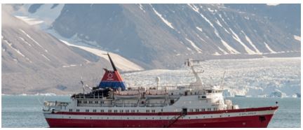
Arctic Cruises Are Extinction Tourism By Another Name Capt. Trevor Greene
 Concepts of Thinking: Geographic Perspective, Spatial Significance, Patterns and Trends, Interrelationship
Inquiry: How might tourist enjoy the Arctic without destroying it? What have been solutions in other similar situations? Could these solutions work for the the Arctic?
Activity: Map out the areas of greatest impact. Conduct an issue analysis and add to map the stakeholders. Determine a best fit solution and communicate to an appropriate audience via story map.
 Concepts of Thinking: Geographic Perspective, Spatial Significance, Patterns and Trends, Interrelationship
 Concepts of Thinking: Spatial Significance, Patterns and Trends, Geographic Perspective
Inquiry: In a world that is able to produce a surplus of food why are people still allowed to go hungry? How might a countries hunger rating change if only looking at domestic data (Canada as an example)?
Activity: Determine the stakeholder and conduct an issue analysis. Create flow map of the distribution of food. Add to the the flow of resource and aid countries around the world are involved in. Other data. Do any patterns appear? What might be some conclusions that can be made about food scarcity and Geographic Perspective and or Spatial significance? Communicate results to an appropriate audience via story map.
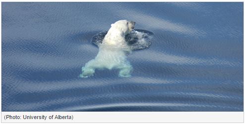
Receding ice causing longer swims for polar bears

Receding ice causing longer swims for polar bears
 Concepts of Thinking: Spatial Significance, Patterns and Trends, interrelationships
Inquiry: How might the increased swim distance impact the polar bears sustainability?
Activity: Create a map of the past and current range of Arctic Ice, polar bear bear range and any other potential contributing factor. Make predictions as to how far the polar bears may have to swim in the future and determine the impact. Communicate to an appropriate audience possible solutions to this problem via story map.
Study finds moose are on the move as the north warms Posted by Rachael Kelly in Wildlife
 Concepts of Thinking: Spatial Significance, Patterns and Trends, Interrelationship
Inquiry: What might some impacts be to the environment the moose are moving into and the environments the moose are leaving?
Activity: Create a spatial journal outlining the historical moose habitat. Determine the spatial significance of these areas. Using climate change data, make predictions how these spatial significant habitats may change.
Inquiry: How might the increased swim distance impact the polar bears sustainability?
Activity: Create a map of the past and current range of Arctic Ice, polar bear bear range and any other potential contributing factor. Make predictions as to how far the polar bears may have to swim in the future and determine the impact. Communicate to an appropriate audience possible solutions to this problem via story map.
Study finds moose are on the move as the north warms Posted by Rachael Kelly in Wildlife

How Geography Impacts Flu Outbreaks by

Concepts of Thinking: Spatial Significance, Interrelationships, Patterns and Trends
Inquiry: How might Doctors be able to use Geography to manage flu or other illnesses?
Activity: Create a map of resent disease (zika virus) outbreaks to help identify patterns and trends. What might be the spatial significance of these areas? Make predictions on where the virus may move to. Communicate results to an appropriate audience via story map.
Photos From Ecuador Show Devastation After The Deadly Earthquake
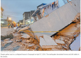 Concepts of Thinking: Spatial Significance, Geographic Perspective, Interrelationships
Inquiry: How might people best help the people who need help? Where might people go to get the aid they need?
Activity: Create a map of the area and the plate boundaries, fault lines and human patterns. Conduct an issue analysis to help determine what could be done. Communicate via story map to the appropriate audience.

Severe drought leaves millions relying on emergency aid
 Concepts of Thinking: Spatial Significance, Interrelationship, Patterns and Trends
Inquiry: What might be the spatial significance of this region that contribute to the drought?
Activity: Gather data on droughts of the region and create a map to help observe patterns and trends. Conduct an issue analysis and add stake holders to the map. Create a story map to communicate results.

Attawapiskat declares state of emergency over spate of suicide attempts By Kate Rutherford, CBC News
 Concepts of Thinking: Interrelationships, Patterns and Trends, Spatial Significance, Geographic Perspective
Inquiry: What might the factors be that are contributing to this community having an enormous suicide rate? What other communities might be facing a similar situation? How might this trend be turned around?
Activity: Create a map to determine the spatial significance of the area. Complete an issue analysis of the problem and and the stakeholders to the map. Communicate potential solution to the appropriate audience via story map.

Farmland prices up 10% last year as property boom spreads to agriculture
CBC News Posted: Apr 11, 2016 8:47 AM ET
 Concepts of Thinking: Spatial Significance, Patterns and Trends, Geographic Perspective
Inquiry: Why might the farmland prices be going up. How does the farmland price increase compare to residential prices? Why might there be a difference?
Activity: Create a spatial journal of houses and farms. Add data such as land use to better discuss the difference. What might the future look like for both type of land use?

Maritime boat building 'boom' fuelled by lobster industry
By Paul Withers, CBC News
 Concepts of Thinking: Spatial Significance,
Geographic Perspective, Interrelationships
Concepts of Thinking: Spatial Significance,
Geographic Perspective, Interrelationships
Inquiry: Why has there been such an "boom" in building lobster boats? What might be the impacts of increased production of lobster boats?
Activity: Gather information and data on lobster "fishing". Conduct an issue analysis. Create a map of the extent of lobster fishing. Evaluate the human ans environmental impacts of increased lobster fishing to determine proper management of the resource. Communicate results to an appropriate audience via story map.

Massive deforestation found in Brazil’s Cerrado

Concepts of Thinking: Interrelationships, Patterns and Trends, Spatial Significance, Geographic Perspective
Inquiry: How might agriculture in the rain forest be sustainable?
Activity: Create a map showing the extent of rain forest deforestation over time. Conduct an issue analysis and add these groups to the map. Create a story map to communicate a solution to the problem.
Canada’s oilpatch suffers biggest drop in investment in almost 70 years, CAPP warns Yadullah Hussain | April 7, 2016 9:42 AM ET
 Concepts of Thinking: Patterns and Trends, Spatial Significance, Geographic Perspective, interrelationships
Inquiry: Why might Canada's Oil patch continue to suffer?
Activity: Conduct an issue analysis and map out the stakeholders. Make predictions on the future of Canada's oil industry and Canada's economy.

Ontario rescinds controversial proposals to ease wolf and coyote hunting regs in north
By Gord Ellis, CBC News
 Concepts of Thinking: Geographic Perspective, Patterns and Trends, Spatial Significance
Inquiry: How might the hunting of such animals impact human and natural systems.
Activity: Create an issue analysis of of the stakeholders. Create a map of the range of the wolf and coyote populations. Add layers such as cities, different animals, and vegetation etc. Determine what should happen next. Communicate results via a story map.

Shoal Lake 40 First Nation Advocates Say More Money Needed For All-Weather Road By The Canadian Press
 Concepts of Thinking: Spatial Significance, Patterns and Trends, Interrelationships, Geographic Perspective
Inquiry: How could a community in Canada be under a boil water alert for so long? How could an all weather road help this community? Might there be other communities in similar situations?
Activity: Create a map showing the spatial significance of Shoal Lake 40.Gather information on other communities under a boil water advisory. Can any patterns be observed? What spatial significance is observed? How can this issue be addressed? Communicate results to and appropriate audience via story map.

Immigrants Beat Canadians At Starting Businesses: StatsCan
The Huffington Post Canada | By Jesse Ferreras
 Concepts of Thinking: Geographic Perspective, Patterns and Trends
Inquiry: Why are immigrants beating Canadians at starting businesses? How might this pattern impact the Canadian Economy?

Blasts at Costa Rica’s Rincón de la Vieja Volcano Hint at Something Big
 Concepts of Thinking: Spatial Significance, Interrelationships
Inquiry: How might this activity impact the region? If people have to evacuate where might they go? How might they get there?
Activity: Create a map of the region with data such as plate boundaries, volcanoes, population distribution to determine patterns and make predictions.
Blasts at Costa Rica’s Rincón de la Vieja Volcano Hint at Something Big

More pain for Canada’s natural gas producers: U.S. drillers ready to pounce and reverse flow northward
Concepts of Thinking: Spatial Significance, Geographic Perspective, Patterns and Trends
Inquiry: Why might Canada be importing it's oil?

Mineral exploration spending expected to plummet this year in Nunavut, Yukon

Concepts of Thinking: Geographic Perspective, Patterns and Trends, Interrelationships, Spatial Significance
Inquiry: How might the reduction in spending impact different parts of the North?
Activity: Answer the inquiry question by: Determine the interrelationships of mining and the community/ the environment by mapping the mines locations and other human activities as well as environmental features (Lakes, rivers, wetlands, etc). Communicate to the appropriate audience solutions to this situation.

February continues streak of record low Arctic sea ice extent
By Natasha Vizcarra, National Snow and Ice Data Center

Concepts of Thinking: Spatial Significance, Interrelationships, Patterns and Trends
Inquiry: How might this pattern of low Arctic Sea ice impact the different interrelationships?
Activity: Create a map to outline the extent of the Arctic sea ice, add other data such as human activity, climate conditions etc. to answer the inquiry questions.

Activity: Create a map to outline the extent of the Arctic sea ice, add other data such as human activity, climate conditions etc. to answer the inquiry questions.
Polar bears migrate north as rising temperatures hasten Arctic ice melt Darryl Fears for the Washington Post
 Concepts of Thinking: Spatial Significance, Interrelationships, Patterns and Trends
Inquiry: How might the migration patterns of the Polar Bears changed? What might be the consequence of such change?
Activity: Create a map to outline migration patterns of Polar bears add other data such as human activity, climate conditions etc. to answer the inquiry questions.
 Concepts of Thinking: Spatial Significance, Interrelationships, Patterns and Trends
Total eclipse: Indonesia witnesses totality as Sun is blocked by the Moon BBC News

Concepts of Thinking: Spatial Significance
Inquiry: Why was the eclipse only visible for this portion of the earth?

True North refugees: Where 25,000 Syrians have settled in Canada
 Concepts of Thinking: Spatial Significance, Patterns and Trends
Inquiry: How might the ideal location for an Syrian refugee family be determined?
Activity: Have a class discussion on the characteristics that should be met to help support Syrian refugee families. Gather Canadian demographic data to map out potential locations. Evaluate the spatial significance of potential locations to determine where new Syrian refugees needs could be best served.

Five reasons we need to protect the Peace-Athabasca watershed
 Concepts of Thinking: Spatial Significance, Interrelationships, Geographic Perspective, Patterns and Trends
Inquiry: Why might this delta be considered one of the most important features of this region?
Activity: Collect and analyse data of the region. Create a spatial journal to elaborate on the spatial significance of the region. Evaluate any patterns and trends that the research has divulged and make suggestions to sustain the watershed. Create a story map to communicate any suggestions developed.
Untapped loans double Canadian banks oil exposure to $107 billion
 Concepts of Thinking: Interrelationships, Geographic Perspective, Patterns and Trends
Inquiry: How might Canadian Banks play a leading role regarding Climate Change?
Activity: Investigate where Canadian banks are investing and why. Compare that with other banks activities around the world. Create a spatial journal of banking activity around the world. Analyse the patterns and trends and communicate suggestions.

CNN Reporting From Cape Breton As Trump-Inspired Spotlight Continues
CP | By The Canadian Press
 Concepts of Thinking: Spatial Significance, Interrelationships, Geographic Perspective
Inquiry: Why might some Americans be looking at moving North if Donald Trump is elected as President?
Activity: complete an issue analysis of this event. Determine the best course of action and communicate via story map to the appropriate audience.

Canada GDP Grew 0.8 Per Cent In Fourth Quarter Of 2015
 Concepts of Thinking: Patterns and Trends, Geographic Perspective, Spatial Significance
Inquiry: How might this growth impact Canadians across the country?
Activity: Collect data on the growth and decline of Canadian economy. Create graphs and charts to represent the patterns and trends of the economy. Determine what impact spatial significance plays in the Canadian economy by mapping certain events/industries that are improving/declining. What are some observations can be made? What predictions can be made? Could this be a go time to buy a house and where might the best place to buy be?

Ice road opens, with limits, to connect Northern Saskatchewan communities CBC News Posted: Feb 28, 2016 8:50 PM CT

Concepts of Thinking: Spatial Significance, Geographic Perspective, Interrelationships
Inquiry: Why are these Northern communities connected by ice roads? How might Climate Change impact connecting the Northern communities in the future?
Activity: Map out the transportation methods of the Northern communities using. Transportation and population data. Create transportation routes when the lakes are covered. If ice roads will not work in the future due to climate change create new routes by adding in points/lines and polygons. Communicate the rational to an appropriate audience.
March 3rd - Climate Change & Agriculture PIR Live Event - Canadian Agriculture Literacy Week 2016
 Concepts of Thinking: Interrelationships, Spatial Significance
Inquiry: How might agricultural practices change due to changes in clime? Where might these changes have the greatest impact? What might some of the impacts be on different populations around the world?
Activity: Investigate the interrelationships of current agricultural practices. Evaluate the role spatial significance plays with regards to certain practices by creating a map in a spatial journal. Analyse the map for patterns and trends. Communicate results making predictions as to how agricultural practice may change due to climate change.

March 3rd - Climate Change & Agriculture PIR Live Event - Canadian Agriculture Literacy Week 2016

Bison On Track To Return To Banff National Park
The Huffington Post Alberta | By Sarah Rieger
 Concepts of Thinking: Interrelationships, Spatial Significance, Patterns and Trends
Inquiry: Why have people decided to try to bring back the Bison to Alberta? How should the herd be managed to ensure its safety?
Activity: Create a story map outlining the plight of the Bison in North America. Be sure to include the impact human activity and communicate a possible outcomes of the reintroduction of Bison into Alberta.
Dalia Mogahed:

Dalia Mogahed:
TED2016 · 16:16 · Feb 2016
 Concepts of Thinking: Geographic Perspective, Patterns and Trends
Inquiry: Why might people judge the group based on the activities of a few? Why might people judge cultural groups with one set of criteria but their own with another set?
Activity: Complete an issue analysis. Understanding the different stakeholders, their values and beliefs develop a plan of action to help reduce the problems associated with judging groups in a negative way.
Posted by Alexandra Pope in Nature on Tuesday, February 23, 2016

Concepts of Thinking: Spatial Significance, Patterns and Trends
Inquiry: Why does temperature change vary from place to place? How has temperature change impacted people in these different areas? How might this climate impact people in the future?
Activity: Create a map of spatial significance indicating places of greatest temperature change. Add data such as land use, human activity, environmental
characteristic to help determine impacts and make predictions if patterns continue. Communicate a possible solution/result via story map.

Vancouver Island’s hinterland attracts affordability refugees desperate to buy a family home
 Concepts of Thinking: Spatial Significance, Patterns and Trends, Interrelationships
Inquiry: Why might the housing in Vancouver be so expensive? Spatial Significance. What might some of the impacts on city policies be? Interrelationships. What might the future hold if home prices continue to climb? Patterns and Trends.
Activity: Create a map of the Vancouver area of human activity, climatic, land use etc data. Analyse the data to help make predictions on the cost of houses, environmental impacts, population distribution etc. regarding the current situation. Communicate developed prediction via a story map.

5 amazing facts about the St. Lawrence River
 Concepts of Thinking: Spatial Significance, Interrelationships
Inquiry: How has human activity contributed o the over all health of the river? Might might need to happen in order to improve the river systems health?
Activity: Create a map of the St Lawrence Waterway. Add to it human activity data to help determine how the rivers health has been impacted and develop a plan to help improve the health of the river system.

Decision on burying nuclear waste near Lake Huron delayed for more study
Published Thursday, February 18, 2016
 Concepts of Thinking: Spatial Significance, Geographic Perspective,
Inquiry: How can nuclear waste be disposed of safely? What is where? How is an ideal waste disposal site selected? Why there? If not here then where should the nuclear waste be disposed of? Why Care?
Activity: Collect information on the characteristics of a nuclear waste disposal site i.e. geology of an area and map out using ArcGIS Online. Add to it data such as population, water and other relevant data (dependent on audience). Do an analysis of the map, such as creating buffers, to determine an idea location to dispose of the waste. Complete an issue analysis and the communicate via story map to the appropriate audience.
"Lead helps guard your health": How U.S. companies sold a toxic product
By


Romeo Dallaire: ISIS Can't Be Defeated Without Strategy To Help Child Soldiers
 Concepts of Thinking: Interrelationships, Geographic Perspective,
Inquiry: Where do Child Soldiers come from? How might children be "trained" to be soldiers? How might Child Soldiers be helped?
Activity: Create a chloropleth map of countries using child soldiers. Add to it country of origin for the children soldiers. Spatial Significance. Conduct an issue analysis of the issue and communicate a potential solution.
Extension: graph out statistics on Child Soldiers to determine patterns and trends and make some predictions.

U.N. working group suggests U.S. work on racial reconciliation By

What are the top global risks for 2016?
 Concepts of Thinking: Spatial Significance,
Geographic Perspective, Patterns and Trends
Concepts of Thinking: Spatial Significance,
Geographic Perspective, Patterns and Trends
Inquiry: How were these risks established?
Activity: Map graph and chart the data for interpretation. Make predictions on what the future risks might be and where they may be located with supporting information.

Exploring Humanitarian Law (EHL)
 Concepts of Thinking: Geographic Perspective, Spatial Significance, Interrelationships, Patterns and Trends
Activity: Use this resource to meet Geographic curriculum expectations for wide range of courses.

‘Dear Dad, I’m Going to Be Called a Whore’. Her Powerful Video Is Now Moving Millions.
1-in-3 women worldwide will experience physical or sexual violence in their lifetime…
 Concepts of Thinking: Patterns and Trends, Spatial Significance, Geographic Perspective, Interrelationships
Inquiry: How might a society deal with the problem of violence against women? How is it possible for people to treat people so poorly, it's 2016?
Activity: Create a spatial journal of violence against women, locally, nationally, internationally (What is where?). Explore to data for patterns and trends (Why there?). Develop an action plan that could be introduced to help reduce the incidence of violence against women locally, nationally, internationally. Communicate the results to the appropriate audience (Why Care?).

Rescuers race to save dozens trapped under rubble of Taiwan earthquake
 Concepts of Thinking: Spatial Significance, Patterns and Trends
Inquiry: Why were the apartments near by the collapsed building not affected to the same extent? How could this collapse have been prevented?

This Talking Bird Is Disappearing From the Wild

Concepts of Thinking: Interrelationships, Spatial Significance,
Inquiry: Where can these birds be found (spatial significance)? What is where? What are some of the circumstances that could be impacting these birds (interrelationships)? What is where? How could this species circumstance be improved? Why care?
Activity: Create a story map to communicate a solution to this problem.

PRO/CON: Should the U.S. rely on nuclear power to fix climate change?
By

Palestinian families homeless as Israeli military demolishes West Bank houses Peter Beaumont in Khirbet Jenbah
 Concepts of Thinking: Spatial Significance, Geographic Perspective, Patterns and Trends, Interrelationships
Inquiry: What might the families, of the demolished homes, have to do to be able to survive being left without a home? Why would the Israeli government believe the demolishing of homes in the West Bank?
Activity: Gather and Organize data on the problem of the West Band. Use an issue analysis chart. What is Where? Interpret and analysis the data by creating a spatial journal of the problem. Why there? Evaluate and draw conclusion and devise a solution to the problem that can be share with the stakeholders. Why care?
 Concepts of Thinking: Spatial Significance, Geographic Perspective, Patterns and Trends, Interrelationships
Small business owners hope Syrian refugees can fill some long vacant positions
Dan Kelly | February 1, 2016
 Concepts of Thinking: Geographic Perspective, Interrelationships, Patterns and Trends, Spatial Significance
Inquiry: Why might there be job vacancies in an economy that has unemployment?
Concepts of Thinking: Geographic Perspective, Interrelationships, Patterns and Trends, Spatial Significance
Inquiry: Why might there be job vacancies in an economy that has unemployment?
Activity: Gather data on the Canadian economy to determine where (spatial significance) there are vacancies as well as data on where refugees/immigrants are settling in Canada, create maps to help analyse the data to find a conclusion (patterns and trends, interrelationships). Develop a proposal, if needed, to match settlement patterns with job vacancy patterns (geographic perspective).

Final agreement reached to protect B.C.’s Great Bear Rainforest
BELLA BELLA, B.C. — The Globe and Mail
 Concepts of Thinking: Spatial Significance, Geographic Perspective, Patterns and trends
Inquiry: What is the spatial significance of the Great Bear Rain-forest? What is where? Why is this agreement so important? Why there? How has this agreement met the needs of the different stakeholders? How might this agreement reduce the impact on the Rain-forest? Why care?

Animal rights groups protest Ontario's proposed wolf hunting rule changes
 Concepts of Thinking: Geographic Perspective, Interrelationships
Inquiry: Why might the Ministry of Natural Resources and Forestry be thinking about changing rules around hunting wolves in Ontario?
Activity: Have students create an Issues Analysis Chart on the issue to determine a possible solution to the problem. Create a map outlining the range of the wolves territory, settlements, and human activities to help support the solution. Communicate with an appropriate audience to implement the solution.

Canadian Economy Expands In November, But Half Of Industries Have Shrunk In Past Year
Concepts of Thinking: Patterns and Trends, Interrelationships
Inquiry: What might be the spatial significance of industries that are shrinking? What is where? How might this economic pattern impact Canadians? Why care?

Scientists Discover a New Source of Atmospheric Carbon Dioxide JoAnna Wendel, Staff Writer, Earth & Space News

Concepts of Thinking: Interrelationships, Spatial Significance
Inquiry: Where might the source of CO2 off gassing along the Rift Valley be coming from? What might some human impacts be to this source of CO2?
Activity:
Determine characteristics that are unique to this CO2 type (Why there?)and map out (ArcGIS Online)other locations that could be contributing CO2 in the same manner (What is where?). Add in fault lines, cities, and other data that could be relevant to make predictions (Why care?).
Determine characteristics that are unique to this CO2 type (Why there?)and map out (ArcGIS Online)other locations that could be contributing CO2 in the same manner (What is where?). Add in fault lines, cities, and other data that could be relevant to make predictions (Why care?).
By 01.28.16
 Concepts of Thinking: Patterns and Trends, Interrelationships, Spatial Significance
Inquiry: What might be the best relocation response be for emergency crew to the "Big One"?
Activity: Gather data to map (ArcGIS Online) out earthquake activity and create buffers to represent the magnitude (How far it can be felt). What is where? Add in data such as plate boundaries to help determine Why there? Add in cities to determine who might be impacted and where possible safe zone may be located. Devise a response plane to the "Big One". Why care?

Will new maternity law help keep Indian women in work?
 Concepts of Thinking: Interrelationships, Spatial Significance, Geographic Perspective, Patterns and Trends

Inquiry: How has the maternity leave in India changed, interrelationship? How could a common maturity leave policy for working women be developed to better support the women, geographic perspective? How does Canada's maternity leave policy compare?
Activity: Create a spatial journal of maternity leave policies. Analyse to determine Spatial Significance, Patterns ad Trends. What is where? Why there? Devise a plan to help policy makers create maternity policies that can benefit all stakeholders. Why care?
15 Endangered Cities That May Be Flooded By Climate Change
by
 Concepts of Thinking: Spatial Significance, Patterns and Trends, Interrelationships
Inquiry: Where will the residents city go and how do they get there when/if this happens? Why is this a potential threat for so may people?
Problem Based Learning: Use ArcGIS Online to create a map predicting the impacts of rising sea levels. See Mapping Our World

I Support The Energy East Pipeline As A Pragmatic Environmentalist
 Concepts of Thinking: Geographic Perspective, Interrelationships, Spatial Significance, Patterns and Trends
Inquiry: How could our society, the world, actually become an oil free society? What might some of the consequences be?
Problem Based Learning: Gather information on the stakeholders developing geographic perspective. Create a spatial journal of this issue to determine spatial significance. Analysis the patterns and trends and develop a solution that would work best for the majority of the stakeholders, including the environment.

Could What Happened in Flint Happen Anywhere?
 Concepts of Thinking: Geographic Perspective, Interrelationships, Spatial Significance
Inquiry: How did the water get so contaminated it started to break down the pipes made to transport it? How can this water problem be solved? How might this issue impact people around the world?
PHOTOGRAPH BY WILLIAM ARCHIE, DETROIT FREE PRESS/ZUMA/CORBIS
Problem Based Learning: What is where? Why there? Why care? Create an Issues Analysis Chart for this problem. What out what is known in ArcGIS Online i.e. where does the water come from, what goes into the water i.e human activities, communities and anything else that may help with the analysis. Make predictions and develop a potential solution to the Flint water crisis.

Oceans to have more plastic than fish by 2050: Report

Concepts of Thinking: Interrelationships, Patterns and Trends, Geographic Perspective, Spatial Significance
Problem Based Inquiry: How might the plastic be removed from the oceans? Why is ti that only 5% of plastics is recycled?

 Concepts of Thinking: Patterns and Trends, Spatial Significance,
Inquiry: What was so special, environmentally, that could have caused 2015 to break all heat records?
Activity: Map out areas that showed the greatest temperature difference.

Activity: Map out areas that showed the greatest temperature difference.
The 20 Best Places To Visit In Canada for 2016 Vacay.ca Concierge to Canada
 Concepts of Thinking: Spatial Significance, Patterns and Trends, Interrelationship
Activity: Map out the locations using ArcGIS Online to determine the spatial significance of the locations. Observe any patterns and trends that emerge? What might account for these patterns? Add Layers such as Cities and Transportation methods to aid in the analysis.

Valentino's African-Inspired Spring 2016 Campaign Accused Of Cultural Appropriation
 Concepts of Thinking: Interrelationships, Spatial Significance, Patterns and Trends
Inquiry Questions: Why might copying culturally significant fashion be considered Cultural Appropriation? How might it be possible to use other cultural influences in a respectful manner?
Problem Based Learning: Develop a strategy that fashion houses/designers can follow to reduce cultural appropriation but at the same time allow for the appreciation of the cultural dress.

Zika virus up date:
Hawaii baby born with small head had prior Zika infection

Zika virus prompts travel warning for pregnant Canadians
By: Sheryl Ubelacker The Canadian Press, Published on Fri Jan 15 2016
 Concepts of Thinking: Patterns and Trends, Spatial Significance, Interrelationships
Inquiry: What are the climatic conditions that that allow for the transmission from mosquito to humans? What is where? Where on Earth are these conditions found? Why there? How might the transmission of the Zika virus be stopped? If it can't be stopped how might transmission be reduced Why care?
Activity: Create a spatial journal or story map show when and where (places) the virus has spread to. Determine which other places (spatial significance) around the world have similar climatic conditions (interrelationships) where the virus may flourish and locate them on the map. Make some observations to determine patterns and trends to help the medical industry reduce infection rates. compare with an industry map.

Alex — the first January hurricane since 1938 — bears down on island nation with 140 km/h winds
 Concepts of Thinking: Interrelationships, Spatial Significance, Patterns and Trends
Activity Idea: Use Windyty to get up to date information on Alex. Using ArcGIS Online, analyze the weather patterns to determine where Alex may move to. What has contributed to the development of such a storm (Why there)? Are there any locations that need to be worried I (What is where)? How might be worried about the storm and what actions/percautions might be undertaken (Why care)?

Earthquakes in Alberta to become more frequent and stronger, expert says
 Concepts of Thinking: Spatial Significance, Patterns and Trends, Interrelationship, Geographic Perspective
Activity Idea: Identify the problem, determine the perspectives (What is where? Why there?), and come up with potential solution for the issue (Why care?). Communicate (including maps) the solution to an appropriate audience.

Fox Creek fracking operation closed indefinitely after earthquake
 Concepts of Thinking: Geographic Perspective, Spatial Significance
Activity Idea: Use ArcGIS Online to create a map of Alberta, near Fox River. Use layers such as fault lines, cities, transportation routes, etc. Place on it the the epicentre and the location of the fracking.
Inquiry Question: How might the fracking activity have contributed to the earthquake near Fox Creek? What might be a solution to the fracking issue?

Mapping changes to the World’s urban population between 1950 – 2030

Different types of weather maps.
Ideal for grade 9 Geography Unit 1: Interactions with the Physical Environment

Concepts of Thinking: Spatial Significance, Patterns and Trends
Inquiry: Gather and Organize, Interpret, Evaluate, and Communicate
Windyty is a useful tool for watching all elements of weather, determine spatial significance, patterns and trends. Students can gather and organize data, evaluate and draw conclusions, and communicate their findings.
 Concepts of Thinking: Spatial Significance, Patterns and Trends
Inquiry: Gather and Organize, Interpret, Evaluate, and Communicate
50 David Bowie moments  Andrew Harrison Monday 11 January 2016 19.25 GMT
Concepts of Thinking: Spatial Significance, Patterns and Trends
Inquiry: Gather and organize data, evaluate and draw conclusions, and communicate ideas
Activity Idea: Create a Story Map of the David Bowies 50 moments from the Guardian. Gather sources need to locate some of the studios, theaters, and other locations. What might be some of the spatial significance of the places Bowie performed at? Can any patterns and trends be found by evaluating the 50 David Bowies moments? How could David Bowie have impacted different cultures?

50 David Bowie moments
 Andrew Harrison Monday 11 January 2016 19.25 GMT
 Concepts of Thinking: Spatial Significance, Patterns and Trends
Inquiry: Gather and organize data, evaluate and draw conclusions, and communicate ideas
Activity Idea: Create a Story Map of the David Bowies 50 moments from the Guardian. Gather sources need to locate some of the studios, theaters, and other locations. What might be some of the spatial significance of the places Bowie performed at? Can any patterns and trends be found by evaluating the 50 David Bowies moments? How could David Bowie have impacted different cultures?
NASA Examines Global Impacts of the 2015 El Niño Credits: NASA
 Concepts of Thinking: Interrelationships, Spatial Significance, Patterns and Trends
Inquiry Questions: How does El Nino impact the interrelationship between humans and the environment? How does spatial significance contribute to the impacts of El Nino? How might patterns and trends of this environmental event be used to reduce its impacts?
Activity idea: Have students gather and organize data on El Nino to develop ideas into how to reduce its impacts on vulnerable communities around the world.
Six graphics that explain climate change Concepts of Thinking: Interrelationships, Patterns and Trends, Spatial Significance, Geographic Perspective
Inquiry Questions: What is the problem with Climate Change (What Is Where?)? What is the spatial significance of locations impacted the most by Climate Change (What Is Where?)? Why is Climate Change happening (Why Care?)? From a geographic perspective, what are the effects of Climate Change in my community? Looking at patterns and trends, what will the future look like as a result of Climate Change? What are possible solutions to the Climate Change problem ?

Six graphics that explain climate change

African demography
The young continent
With fertility rates falling more slowly than anywhere else, Africa faces a population explosion | MERTULE MARIAM, ETHIOPIA |
 Concepts of Thinking: Patterns and Trends, Spatial Significance, Geographic Perspective
Inquiry Questions: How might the population change impact the geographic perspective? How is the spatial significance of Africa impacting the population trends? How might the patterns and trends of the population of the continent of Africa impact different societies? How might population growth rate compare in different parts of the continent? What is spatial significant about the regions that are growing fast, regions that are growing slowly?

Typhoon Nona paralyses central Philippines
 Concepts of Thinking: Interrelationships, Spatial Significance, Patterns and Trends
Inquiry Questions: How does spatial significance contribute to the power and destruction of the Typhoon? How could buildings be built to withstand such Typhoons (Interrelationships)? How can people prepare for Typhoons to help reduce the risk/damage?
Activity Idea: Have students use ArcGIS Online or black-line master to create a spatial journal of the Typhoons that have hit this area over the past 10 years. Are there an Patterns that can be observed? How can you account for this pattern?
 Concepts of Thinking: Interrelationships, Spatial Significance, Patterns and Trends
Canada's Most Expensive Places To Buy A Home Illustrated In 1 Infographic
Posted: Updated:
 Inquiry Questions: What might account for such a variation in housing prices in Canada? How might housing price change in the future?
 Inquiry Questions: What might account for such a variation in housing prices in Canada? How might housing price change in the future?
 As Indonesia's Annual Fires Rage, Plenty Of Blame But No Responsibility NOVEMBER 01, 2015 ANTHONY-KUHN NPR
Abdul Qodir/AFP/Getty Images

Concepts of Thinking: Interrelationship, Geographic Perspective, Spatial Significance, and Patterns and Trends
Inquiry: Where did the fires start? What is where?
Why do these fires occur yearly? Why there?
How are these fires impacting local and global populations? Why care?
How might the occurrence of these fires be prevented? Why care?
Activity: Map out the location of the palm oil plantations. Answer What is where? Why there? why care? Add to the that map the destination locations of palm oil products. Answer What is where? Why there? Why care?
Can students come up with a potential solution to the yearly occurrence while taking into account the different stakeholders?
The NASA GEOS-5 model is sensitive enough to show sulfur dioxide emissions from ships moving along major shipping lanes.
 Concepts of Thinking: Interrelationship, Spatial Significance, and Patterns and Trends
Inquiry question:
What is spatially significant about the shipping lanes? What is where?
Why do the shipping lanes follow the pattern that they do? Why there?
How will sulfur dioxide impact the interrelationship of people living near the shipping lanes? Why care?

The NASA GEOS-5 model is sensitive enough to show sulfur dioxide emissions from ships moving along major shipping lanes.

China ends one-child policy, will allow two children for all couples
 Concepts
of Thinking: Geographic Perspective, Patterns and Trends, and Interrelationship.
Concepts
of Thinking: Geographic Perspective, Patterns and Trends, and Interrelationship.
Inquiry
questions: How might this policy impact of local and global demographic
patterns and trends?
How
might this population policy impact the interrelationship with humans and the
environment?
BEIJING — The Globe and Mail
Published
Last updated

Whale-watching boat tragedy caused by freak wave, say investigators
 Concepts of Thinking: Interrelationships, Spatial Significance
Inquiry questions: What is the spatial significance of the area that could have contributed to the formation of a rogue wave?
Chris McGreal in Tofino
News / Atkinson Series

News / Atkinson Series
Temporary foreign workers help drive Fort McMurray’s 24-7 economy
 Concepts of Thinking: Geographic Perspective, Interrelationships, and Patterns and Trends
Inquiry question: How might the increased number of foreign workers impact local communities?
Source: Toronto Star
Curriculum connection Strand D: Changing Populations, Grade 9 Geography
Concepts of Thinking: Patterns and Trends, Spatial Significance, Geographic Perspective, and Interrelationships

Source: Toronto Star

Immigration maps
The following maps and charts are based upon data obtained from Citizenship and Immigration Canada, which covers 2001-2011. The data contains records of applications to immigrate to Canada, including year, country of birth and immigration category. Please refer to our glossary for a description of all these categories, and to our welcome page for more information about the maps and charts.

Concepts of Thinking: Spatial Significance, Geographic Perspective, Patterns and Trends
Inquiry Question: Where is Canada receiving the most immigration applications from? Why are these countries send so many applications? Why should Canada be looking at these applications?

Immigration timeline

Concept of Thinking: Spatial Significance, Geographic Perspective, Patterns and Trends
Lesson idea: create a spatial journal using the information from the time line to facilitate the analysis of the information.
Inquiry question: What are patterns appear? How does location (spatial significance) impact Canada’s Immigration History? How could Geographic Perspective impact Immigration Policy?
Justin Trudeau begins first full day as Canada's prime minister-designate
 Concepts of Thinking: Geographic Perspective
Lesson Idea: Minds On-What Is Where? Why There? Why Care?
Killer whale with dolphin pod off Nova Scotia a rare sight

Killer whale with dolphin pod off Nova Scotia a rare sight
 Concepts of Thinking: Interrelationships, Geographic Perspective,
Lesson idea:
Investigate What Is Where? Nova Scotia
Why There?
Why Care?
Why might this be of interest?
GLOBE LEADERS’ DEBATE

Harper, Mulcair, Trudeau lock horns over sluggish economy
The Globe and Mail
Published
Last updated
 Concepts of Thinking: Geographic Perspective, Spatial Significance
Lesson idea: How might location impact a voters view on an issue? Map it out. What are some of the patterns that emerge? Can you make a prediction on the out come of the election at this point? Continue following the election.
Extension: create a spatial journal of where the politicians have campaigned.
Chile earthquake: one million people evacuated after 8.3 magnitude quake – live updates
Waves of up to 4.5m high reported in some parts of Chile as tsunami warning issued for Peru, Chile, New Zealand, California and Hawaii
Concepts of Thinking: Spatial Significance, Geographic Perspective, Patterns and Trends

Barrow, Alaska

Concepts of thinking: Spatial significance, geographic perspective, interrelationships
Barrow, Alaska

Ageing UK population will increase strain on public spending, OBR warns
Office for Budget Responsibility says that national debt would come down from its current 80% of GDP to 54% by the early 2030s and then start rising again
 Concepts of thinking: Patterns and trends, geographic perspective
How might this compare to Canada's population patterns?
Ageing population is going to push up public spending, according to the Office for Budget Responsibility. Photograph: F1 Online / Rex Features/F1 Online / Rex Features
Nepal earthquake: Devastation in maps and images 28 April 2015 BBC
Concepts of Thinking: Spatial Significance (why is the earthquake location so important?) Interrelationships (why was it that so many buildings were not livable after the quake?),
Geographic Perspective (how might people be able to best help the situation in Nepal?),
Patterns and Trends (Why would so many people live in an area that has the potential or such damage? What, if any, evidence is there that this may happen again?)
What could be done to ensure that this type of destruction could be reduced in the future?

Nepal earthquake: Devastation in maps and images 28 April 2015 BBC
Clockmaker John Harrison vindicated 250 years after ‘absurd’ claims
The pendulum clock of Longitude hero John Harrison is tested and declared a masterpiece
 Concept of Thinking: Spatial Significance
A series of pictures
showing some effects of population increase and the stress on the environment
that comes with it.
http://tinyurl.com/effects-of-population-increase

This two web page were posted earlier but I thought it would be worth posting again.
Gapminder and Worldmapper are websites that are inter active graphs, maps, and charts. Supporting lessons for Gapminder are also available.
Concepts of Thinking: Patterns and Trends, Geographic Perspective

http://www.worldmapper.org

A fun video that gets across the mapping essentials.
Suggested use as a minds on.

Geographic Perspective: Spatial Significance
They Flew a Drone Over a Pig Farm to Discover It’s Not Really a Farm. It’s Much More Disturbing.
http://tinyurl.com/pig-farm-from-the-air

Concepts of Thinking: Spatial Significance, Geographic Perspective
NASA: Global Climate Change, Vital Signs of a Plant
Great slides of Then and Now dealing with Climate Change.
Concepts of Geographic Perspective: Spatial Significance, Patterns and Trends, Interrelationships
A series of pictures showing some effects of population increase and the stress on the environment that comes with it.
http://www.worldmapper.org
A fun video that gets across the mapping essentials.
They Flew a Drone Over a Pig Farm to Discover It’s Not Really a Farm. It’s Much More Disturbing.
http://tinyurl.com/pig-farm-from-the-air
NASA: Global Climate Change, Vital Signs of a Plant
Wind Power Around the World
Here is a great graphic showing the amount of energy generated from wind around the world.
Concepts of Geographic Thinking: Spatial Significance, Patterns and Trends
Suggested use: Have students create a spatial journal using ArcGIS on line.
Below are two websites dealing with climate and climate change. There are several interesting links associated with these sites.
This website has a variety of resources relating to different aspects of the water cycle. 

Roam the World in (Almost) Real Time
Concepts of Thinking: Geographic Perspective, Spatial Significance
Florida banned state workers from using term 'climate change' – report
Florida is threatened by climate change, according to the 2014 US national climate assessment. Photograph: Sipa Press/Rex/Sipa Press/Rex
Geographic Concepts of Thinking: Geographic Perspective, Spatial Significance
AQUEDUCT World Resource Institute
A great resource for World Issues
Roam the World in (Almost) Real Time
Florida banned state workers from using term 'climate change' – report
AQUEDUCT World Resource Institute
The Shocking Truth About What It Would Cost Walmart If It Paid a Living Wage.
In two minutes, economist Robert Reich completely destroys every possible excuse for Walmart’s low wages…
Click on the link: http://tinyurl.com/qaksn92
Concepts of Thinking: Geographic Perspective, Interrelationships, Patterns and Trends,
The Haiti earthquake five years on - then and now
- Click each image to show the same location, five years on

This Is What A World Map Looks Like When Scaled According To Population Size

Julia Roberts Tells Everyone In the World to Stop Pretending Like Facts Don’t Exist.
This is a good clip to show the Gaia Hypothesis.
Concepts of Thinking: Geographic Perspective, Interrelationships
This is a nice video as a minds on activity.
Some Strange Things Are Happening to Astronauts Returning to Earth.

The video deals with Geographic Perspective
Malawi floods leave grim legacy of death, destruction and devastation

This is a nice video as a minds on activity.
World's cities experiencing more heatwaves, study shows
Number of extremely hot days a year has increased in hundreds of cities since the 1970s years, with frequencies peaking in the last five years

More extreme heat, less cold spells and less high winds is the weather trend for many of the world’s cities, a new study shows. Photograph: Richard Baker/Corbis
Concepts of Thinking: Geographic Perspective, Spatial Significance, Patterns and Trends, Interrelationships
The aerial delivery of relief supplies has revealed the tragic human and environmental cost of the floods that hit Malawi following torrential rains

The floods in Malawi have displaced at least 174,000 people, sweeping away homes and claiming untold lives. Photograph: Shiraaz Mohamed/AP
The aerial delivery of relief supplies has revealed the tragic human and environmental cost of the floods that hit Malawi following torrential rains
22 Maps of Caanada as you’ve never seen it before
Beijing smog makes city unliveable, says mayor
Polluting factories and skyrocketing vehicle ownership blamed as report finds tourism to Chinese city falls 10% on year before
http://tinyurl.com/smog-in-the-city

A child wears a face mask while walking along a street in Beijing. Photograph: Fred Dufour/AFP/Getty Images
Climate change responsible for super-charging winter storms, scientists say
Concepts of Thinking: Geographic Perspectives, Spatial Significance, Patterns and Trends
Climate change responsible for super-charging winter storms, scientists say
The link below has several articles relating to Oil and the Environment from around the world. The Concepts of Thinking addressed through the link are: Geographic Perspective, Spatial Significance, Interrelationships.
http://www.theguardian.com/environment/oil
White House unveils plan to open Atlantic waters to offshore oil drilling
Move to lease large swaths of ocean along east coast and double down in Gulf of Mexico oddly comes in wake of attacks against right for climate change denial
 This could be a common sight along the Atlantic coast horizon after the Obama administration moved to open a large swath of the Atlantic seaboard to oil drilling. Photograph: Cristobal Garcia/EPA
Concepts of Thinking: Spatial Significance, Geographic Prespective
US Senate refuses to accept humanity's role in global climate change, again
Senators accept global warming is not a hoax but fail to recognise human activity is to blame, nearly 27 years after scientists laid out man’s role.
 Concepts of Thinking: Geographic Perspective, Interrelationships
An Esri activity that deals with the effects of Climate Change can be found by clicking on the link below:
Running hot and cold
The link below that ranks countries on different characteristics. Spatial Journals could be created using ArcGIS On Line or My Maps (Google).


No comments:
Post a Comment