Tourism desperately wants a return to the ‘old normal’ but that would be a disaster. The Conversation, Canada
 Concept of Thinking: Geographic Perspective, Patterns and Trends, Interrelationships
Inquiry: Why might going back to the old way of travel not be the best for the Earth? How should the travel industry rebuild after COVID-19?
Activity: Collect data on the travel industry. Evaluate the data to determine environmental impact of travel during COVID. Create a spatial journal of evidence of this impact. Conduct an issue analysis to determine the best way forward for the travel industry and communicate via story map.
WTTC: Travel and Tourism is Zambia’s 2018 fastest-growing national economic sector, Global Travel Industry News

Concepts: How might this increase in Tourism to Zambia impact their population?
Activity: Gather and organize (code) data on Zambia's tourism industry. Conduct an issue analysis to determine the perspectives of stakeholders. Create a spatial journal of the information where some impacts may be found. Create a story map to help communicate the result and suggest some changes that might be made so more of the population can benefit from this industry.
 Concepts of Geographic Thinking: Spatial Significance, Patterns and Trends
Inquiry: Why might the release of Sulphur Dioxide into the atmosphere from a volcanic eruption be of concern?
Activity: Collect data on the impacts of sulphur dioxide in the atmosphere. Determine the connection between sulphur dioxide release and spatial significance by creating a spatial journal of volcano type and amount of sulphur dioxide release and observe for any patterns and trends. From a geographic perspective, how might these events, the release of sulphur dioxide into the environment, be of concern to stakeholders? Conduct an issue analysis to gain perspective and develop an action plan to deal with these types of events and communicate the results as a story map.

#Travelgoals: why Instagram is key to understanding millennial tourism

Inquiry: How might increased Instagram use impact travel/tourist destinations?
Activity: Gather data on the top destination before instagram (April 2012) and create a spatial journal. Collect data on sites that instagram has made popular and add this to your spatial journal. Observe for patterns and trends. How might spatial significance impact the popularity? Conduct an issue analysis of to develop a plan of action to maintain the location. Create a story map to communicate your results.

Canadian drug mule sentenced in Australia for cocaine cruise The Canadian Press

Inquiry: How might drug smuggling impact the Travel industry? Who really is the criminal and how should they be treated?
Activity: Gather data on where this type of smuggling takes place. Create a spatial journal indicating place of origin and destination. Conduct an issue analysis and develop a strategy to deal with this issue. Communicate your result to an appropriate audience via story map.

Fishing for plastic: the Amsterdam canal tour with a difference The Guardian
 Concepts of Thinking: Interrelationships, Geographic Perspective, Spatial Significance
Inquiry: Where else might this type of community action be necessary? How might this type of action look in your community? What might be a better solution for tackling global plastic pollution?
Activity: Gather data on the plastic pollution origins. Create a spatial journal of where plastic pollution is a problem. Conduct an issue analysis to develop an action plan. Create a story map to communicate action plan to an appropriate audience.

Stronger storms mean new 'category six' scale may be needed

Inquiry: How might a category 6 storm impact communities? How might global warming impact these storms?
Activity: Gather data on storms to determine where they occur and at what frequency and create a spatial journal. Use some global warming data to evaluate its' impact on storm severity. Conduct an issue analysis and communicate results via story map.
The White Darkness
 Concepts of Thinking: Spatial Significance, Interrelationships,
Inquiry: Why might people want to explore Antarctica? How might this journey impact communities?
Activity: Create a story map of this solitary journey across Antarctica using The White Darkness. COmmunicate this to an appropriate audience.

Inquiry: How might a category 6 storm impact communities? How might global warming impact these storms?
Activity: Gather data on storms to determine where they occur and at what frequency and create a spatial journal. Use some global warming data to evaluate its' impact on storm severity. Conduct an issue analysis and communicate results via story map.
The White Darkness

Concepts of Thinking: Spatial Significance, Interrelationships,
Inquiry: Why might people want to explore Antarctica? How might this journey impact communities?
Activity: Create a story map of this solitary journey across Antarctica using The White Darkness. COmmunicate this to an appropriate audience.
Winter sun destinations: 10 top trips
 Concepts of thinking: Spatial Significance, Patterns and Trends
Inquiry: Where might the best vacation spot for you be? What might be the most important criteria when deciding the best location?
Activity: Create a spatial journal of the top location. Examine for spatial significance and patterns and trends. Conduct an issue analysis of a location to determine an action plan on how to promote the location via story map.

This map shows every ship at sea in real time Image: REUTERS/Chris Helgren
 Concept of Thinking: Patterns and Trends, Spatial Significance
Inquiry: Why might these ships take these routes? What might these ships be transporting? What might the environmental impacts be with all this shipping?
Activity: Gather information on the ports of origin of the ships. GAther data on weather and conduct an issue analysis to determine when weather could impact shipping by making it to dangerous and create an action plan to deal with the situation i.e. alternate routes. Communicate via story map.

10 of the best Christmas shopping cities in Europe
 Concepts of Thinking: Spatial Significance, Patterns and Trends, Interreltionships
Inquiry: What makes a city the best Christmas shopping?
Activity: Create a spatial journal of theses cities to observe any patterns or trends. Conduct an issue analysis to better understand the ranking process. Make suggestions on what might be required for other cities to make the list next time and communicate in a story map.

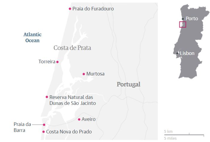
Europe’s hidden coasts: Costa de Prata, Portugal Kevin Gould Thursday 18 May 2017 06.30 BST
Otherworldly Destinations Here on Earth
National Geographic
 Concepts of Thinking: Spatial Significance, Patterns and Trends
Inquiry: How might these land forms have been formed?
Activity: Investigate of these land forms were created. Create a spatial journal of these places describing the formations. What might account for any patterns observed? Communicate via story map.

Dead Sea drying: A new low-point for Earth By Kevin Connolly, BBC Middle East correspondent, 17 June 2016
 Concepts of Thinking: Spatial Significance, Patterns and Trends, Interrelationships, Geographic Perspective
Inquiry: How might human activity contribute to the state of the Dead Sea? What might be the best solution to dealing with the decrease water level of the Dead Sea?
Activity: Create a spatial journal of the area taking not consideration drainage basins, human settlement, human activity, and climate patterns. Conduct an issue analysis to evaluate perspectives. Determine a plausible solution and communicate via story map to an appropriate audience.

Cambodia revives train service between Phnom Penh and Sihanoukville
 Concepts of Thinking: Spatial Significance, Patterns and Trends
Inquiry: Why was the train survive interrupted? How might this revived service impact communities along the route?
Activity: Conduct an issue analysis of the situation. Create a spatial journal of the places along the way that might be impacted by this service. Create a story map outlining how this service will impact local business.

India’s Severe Drought Causing Havoc
 Concepts of Thinking: Spatial Significance, Patterns and Trends, Interrelationships, Geographic Perspective
Inquiry: How could these conditions have been predicted and/or prevented? How might India's drought impact other parts of the world?
Activity: Conduct an issue analysis of the problem. Create a spatial journal of the stakeholders, physical and climatic factors. Evaluate graphs and charts of climate. Develop a potential solution to the problem and communicate via story map to the appropriate audience.
 Concepts of Thinking: Spatial Significance, Patterns and Trends, Interrelationships, Geographic Perspective
Returning Fort McMurray residents face long road to recovery By Amy Husser, CBC News
 Concepts of Thinking: Interrelationships, Patterns and Trends, Geographic Perspective
Inquiry: How might be the focus of Fort McMurray's redevelopment impact the future growth of the city?
Activity: Create a spatial journal of the resources currently supporting Fort McMurray. Add possible alternative/new resource opportunities, natural features, and human activity data. Evaluate the map to develop a plan for redevelopment that could better protect the city from being a boom bust, one resource, based city. Communicate the plan to the appropriate audience via story map.

The boiling river in the Amazon Helen Walters
 Concepts of Thinking: Spatial Significance, Interrelationships, Geographic Perspective
Inquiry: What might be causing the water to heat up so much? Why is the location if such an extreme river not well known? What might be some impacts if the location of this river becomes widely known?
Activity: Class discussion on what might be causing the water to be so hot. Investigate other location i.e. Iceland, Yellowstone National Park. Create a spatial journal of the plate tectonics, with geyser locations to determine the spatial significance. Observe the pattern and trend that appear. Locate the Peruvian part of the Amazon river basin. Is there a similar pattern of spatial significance? Could this be the location of the Boiling River? Conduct an issue analysis and determine what should be done with regards to this location to ensure its sustainability. Create a story map to communicate the results.

Inside the world's largest cruise ship, Harmony of the Seas
 Concepts of Thinking: Spatial Significance, Interrelationships, Geographic Perspective, Patterns and Trends
Inquiry: Where might some destinations for the ship be? How might this type of tourism impact ecosystems?
Activity: Create a spatial journal of locations that this ship might be able to travel to. Determine some of the spatial significance of these location. What might some observations be regarding patterns and trends. Create a story map to communicate results.
CAPTIVE MARKET: UNDERSTANDING NUNAVUT’S COMPLEX AIRLINE INDUSTRY
 Concepts of Thinking: Spatial Significance, Patterns and Trends, Geographic Perspective
Inquiry: How might increased travel to the North and Iqaluit’s new international airport impact local ecosystems?
Activity: Create a spatial journal of the region containing human and environmental data. Conduct an issue analysis and make a judgement on what would be best for the region. Communicate results to an appropriate audience via story map.
 Concepts of Thinking: Spatial Significance, Interrelationships, Geographic Perspective, Patterns and Trends
Inquiry: Where might some destinations for the ship be? How might this type of tourism impact ecosystems?
Activity: Create a spatial journal of locations that this ship might be able to travel to. Determine some of the spatial significance of these location. What might some observations be regarding patterns and trends. Create a story map to communicate results.
CAPTIVE MARKET: UNDERSTANDING NUNAVUT’S COMPLEX AIRLINE INDUSTRY

Great Barrier Reef bleaching made 175 times likelier by human-caused climate change, say scientists
 Concepts of Thinking: Spatial Significance, Interrelationships, Patterns and Trends
Inquiry: How might be a plausible
Activity: Conduct an issue analysis and map out the data as well as the extent of the bleaching along the Reef. Add to the map human data i.e. distribution, industry etc. Create a story map to communicate your results
Why being a vegetarian traveller is often so hard to swallow Shahnaz Habib
 Concepts of Thinking: Spatial Significance, Patterns and Trends
Inquiry: How might a vegetarian traveller best meet their needs?
Activity: Research where vegetarianism is most common. Create a chloropleth map to communicate research findings. Add other travel information to map such as tourist attractions to determine the best places for travelers to visit and have quality vegetarian meals.
 Concepts of Thinking: Spatial Significance, Interrelationships, Patterns and Trends
Inquiry: How might be a plausible
Activity: Conduct an issue analysis and map out the data as well as the extent of the bleaching along the Reef. Add to the map human data i.e. distribution, industry etc. Create a story map to communicate your results
Why being a vegetarian traveller is often so hard to swallow Shahnaz Habib

Turbulent battle as Golden, B.C., fights to save local river rafting industry
 Concepts of Thinking: Geographic Perspective, Interrelationship, Spatial Significance, Patterns and Trends
Inquiry: How might rafting company ensure that the increased access will not increase environmental impact?
Activity: Conduct an issue analysis and map out the the stakeholders and the site affected. Determine whether or not permission should be given and communicate to an appropriate audience via story map.

Top 10 music festivals in Europe for 2016 Will Coldwell
 Concepts of Thinking: Spatial Significance, Patterns and Trends
Inquiry: What makes an optimal festival location? If the list where to expand to the top 15, where might the next five festivals be located? Why?
Activity: Create a spatial journal of the location to determine a pattern. Is there any part of Europe that is missing? If so what might be needed to fill this space? Communicate results to the appropriate audience via story map.
 Concepts of Thinking: Spatial Significance, Patterns and Trends
10 of the best alternative city breaks in Europe By: Will Coldwell
 Concepts of Thinking: Spatial Significance, Patterns and Trends
Inquiry: Why might these locations be considered the top 10 best alternative? What might be Canada's top 10 best alternative cities?
Activity: Create a map of these locations to observe patterns, if any, that appear. Evaluate each location in Europe for its spatial significance. Create a map of Canada, using the same spatial significance, to locate the top 10 alternative cities. How might these cities be advertised to increase awareness of their uniqueness?
 Concepts of Thinking: Spatial Significance, Patterns and Trends
UK tourists killed by Vietnam waterfall's 'violent waters' Jessica Elgot and agencies

Concepts of Thinking: Spatial Significance, Interrelationships,
Inquiry: How could such an event have been prevented?
Activity: Create a spatial journal that highlights dangerous tourist locations around the world. Identify patterns and trends and develop a travel advisory to help tourist be aware of some of the dangers of travel. Communicate results to an appropriate audience.

Vancouver Island’s hinterland attracts affordability refugees desperate to buy a family home
 Concepts of Thinking: Spatial Significance, Patterns and Trends, Interrelationships
Inquiry: Why might the housing in Vancouver be so expensive? Spatial Significance. What might some of the impacts on city policies be? Interrelationships. What might the future hold if home prices continue to climb? Patterns and Trends.
Activity: Create a map of the Vancouver area of human activity, climatic, land use etc data. Analyse the data to help make predictions on the cost of houses, environmental impacts, population distribution etc. regarding the current situation. Communicate developed prediction via a story map.
12 beaches with wow factor Guardian writers

 Concepts of Thinking: Spatial Significance
Inquiry: What spatial significance gives these locations the WOW factor (other not being in the snow)? Which beach would be the best retreat and for who?
Activity: Do some further research to collect beach data on cost, number of visitors to create an interactive spatial journal. Use proportional size symbols to indicate cost, popularity etc. Which beach is the best and for who?

26 Most Beautiful Winter Cities
 Concepts of Thinking: Spatial Significance, Interrelationship, Patterns and Trends, Geographic Perspective
Inquiry: What might be some common characteristics that make these cities regarded as the most beautiful cities? What might be the most efficient way to visit these locations?
Activity: Create a spatial journal of these most Beautiful cities to help determine spatial significance. What is where? Analyse the characteristic of the places on the map to determine: Why there? Design a route that would be the most efficient for someone to follow and see all these beautiful places.Why care?
Extension: Using the same criteria for what makes the city beautiful, identify other potential cities that could be placed on this list and explain why in a story map.

Exploring Humanitarian Law (EHL)
 Concepts of Thinking: Geographic Perspective, Spatial Significance, Interrelationships, Patterns and Trends
Activity: Use this resource to meet Geographic curriculum expectations for wide range of courses.

Passengers tell of terror as cruise ship battered by nine-metre waves Reuters
 Concepts of Thinking: Spatial Significance, Geographic Perspective
Inquiry: How could such a storm appear without warning? Why didn't the ship avoid the storm by sailing around it?
Activity: Map out the route of a few cruise ships in ArcGIS Online (What is where?). Add in some interesting data about the location (Why there?) . Input some climatic data to and plan the route for the cruise ship that will keep it safe (Why care?).

Zika Virus and Direct Relief's Partner Network Story Map.
 Concepts of Thinking: Spatial Significance, Patterns and Trends, Interrelationships
Inquiry: What might be the impacts of this virus on different communities? How might the infected children be supported in the future?
Activity: Conduct an issue analysis to develop with a possible solution and communicate it to appropriate stakeholders.

The best of Switzerland's city sights: readers’ tips
 Concepts of Thinking: Spatial Significance, Geographic Perspective
Inquiry: What types of characteristics might have been considered to establish the rankings? How where these characteristic established? Why rank the cities?
Activity: Create a spatial journal of the best locations. Evaluate for spatial significance and patterns and trends.

The 20 Best Places To Visit In Canada for 2016 Vacay.ca Concierge to Canada
 Concepts of Thinking: Spatial Significance, Patterns and Trends, Interrelationship
Activity: Map out the locations using ArcGIS Online to determine the spatial significance of the locations. Observe any patterns and trends that emerge? What might account for these patterns? Add Layers such as Cities and Transportation methods to aid in the analysis.

Valentino's African-Inspired Spring 2016 Campaign Accused Of Cultural Appropriation
 Concepts of Thinking: Interrelationships, Spatial Significance, Patterns and Trends
Inquiry Questions: Why might copying culturally significant fashion be considered Cultural Appropriation? How might it be possible to use other cultural influences in a respectful manner?
Problem Based Learning: Develop a strategy that fashion houses/designers can follow to reduce cultural appropriation but at the same time allow for the appreciation of the cultural dress.

Where to go on holiday in 2016
 Concepts of Thinking: Spatial Significance, Patterns and Trends
Activity: Create a Spatial Journal of all the locations and record the spatial significance of each locations What is where? What are the patterns and trends that develop? Why there? How might some of the interrelationship
Guardian writers Friday 1 January 2016 07.00 GMT at these tourist destination impact the local geography? Why care?
 Concepts of Thinking: Spatial Significance, Patterns and Trends
Guardian writers Friday 1 January 2016 07.00 GMT at these tourist destination impact the local geography? Why care?
Zika virus up date:
Hawaii baby born with small head had prior Zika infection

Zika virus prompts travel warning for pregnant Canadians
By: Sheryl Ubelacker The Canadian Press, Published on Fri Jan 15 2016
 Concepts of Thinking: Patterns and Trends, Spatial Significance, Interrelationships
Inquiry: What are the climatic conditions that that allow for the transmission from mosquito to humans? What is where? Where on Earth are these conditions found? Why there? How might the transmission of the Zika virus be stopped? If it can't be stopped how might transmission be reduced Why care?
Activity: Create a spatial journal or story map show when and where (places) the virus has spread to. Determine which other places (spatial significance) around the world have similar climatic conditions (interrelationships) where the virus may flourish and locate them on the map. Make some observations to determine patterns and trends to help the medical industry reduce infection rates. compare with an industry map.

Different types of weather maps.
Ideal for grade 9 Geography Unit 1: Interactions with the Physical Environment

Concepts of Thinking: Spatial Significance, Patterns and Trends
Inquiry: Gather and Organize, Interpret, Evaluate, and Communicate
Windyty is a useful tool for watching all elements of weather, determine spatial significance, patterns and trends. Students can gather and organize data, evaluate and draw conclusions, and communicate their findings.
 Concepts of Thinking: Spatial Significance, Patterns and Trends
Inquiry: Gather and Organize, Interpret, Evaluate, and Communicate
50 David Bowie moments
 Andrew Harrison Monday 11 January 2016 19.25 GMT
Concepts of Thinking: Spatial Significance, Patterns and Trends
Andrew Harrison Monday 11 January 2016 19.25 GMT
Concepts of Thinking: Spatial Significance, Patterns and Trends
Inquiry: Gather and organize data, evaluate and draw conclusions, and communicate ideas
Activity Idea: Create a Story Map of the David Bowies 50 moments from the Guardian. Gather sources need to locate some of the studios, theaters, and other locations. What might be some of the spatial significance of the places Bowie performed at? Can any patterns and trends be found by evaluating the 50 David Bowies moments? How could David Bowie have impacted different cultures?
Ideal for grade 9 Geography Unit 1: Interactions with the Physical Environment
Open weather map is a useful tool also for Travel and Tourism industry when planning on essentials for a location. Patterns can be observed, and spatial significance can be determined.
Concepts of Thinking: Spatial Significance, Patterns and Trends
Inquiry: Gather and Organize, Interpret, Evaluate, and Communicate

Concepts of Thinking: Spatial Significance, Patterns and Trends
Inquiry: Gather and Organize, Interpret, Evaluate, and Communicate
 Andrew Harrison Monday 11 January 2016 19.25 GMT
Top 10 family adventure holidays in Europe Sam Haddad Sunday 10 January 2016 07.00 GMT
 Concepts of Thinking: Spatial Significance, Patterns and Trends, Interrelationships
Activity idea: Create a spatial journal to locate the locations of the top 10 locations. Use proportional size symbols to categorize each location based on cost.
Are there any patterns that evolved? How might this pattern be accounted for?
What are the interrelationships of each location? How might spatial significance account for these interrelationships?
Extension: 1) Do some research to determine the tourist country of origin at each location. Use proportional width arrows on the map to represent number of tourist. Are there any patterns that developed? How can these patterns be accounted for?
2) What might some of the environmental impacts be at each of these locations? Based on different stakeholders, what need to be done in order to help reduce any negative environmental impacts?
 Concepts of Thinking: Spatial Significance, Patterns and Trends, Interrelationships
2) What might some of the environmental impacts be at each of these locations? Based on different stakeholders, what need to be done in order to help reduce any negative environmental impacts?
Avoid These 25 Dangerous Airports At All Costs. Your Life Depends On It.

Concepts of Thinking: Spatial Significance, Patterns and Trends
Inquiry Questions: What criteria might make an airports location dangerous? How might spatial significance contribute to the location of an airport?
Activity: Use ArcGIS Online or a black line master to create a spatial journal of the dangerous airports with a description of the spatial significance. What is the pattern that can be observed from this map, if any? Using the map created come up with alternative locations for these airports to serve the same area but in a safer way.
Searching for the remote: Cabo Raso, Patagonia’s coastal ghost town Allie Lazar
 Concepts of Thinking: Interrelationship, Spatial Significance
Inquiry Question: Why might the spatial significance of this location contribute to it's novelty as a travel destination?
How might the environment and humans interact in this location?
Problem: How could this location be maintained for future generation to observe with little to no negative environmental impact?

Concepts of Thinking: Spatial Significance, Patterns and Trends
Inquiry Questions: What criteria might make an airports location dangerous? How might spatial significance contribute to the location of an airport?
Activity: Use ArcGIS Online or a black line master to create a spatial journal of the dangerous airports with a description of the spatial significance. What is the pattern that can be observed from this map, if any? Using the map created come up with alternative locations for these airports to serve the same area but in a safer way.
Searching for the remote: Cabo Raso, Patagonia’s coastal ghost town Allie Lazar
 Concepts of Thinking: Interrelationship, Spatial Significance
Guardian Travel's year in Instagram: 2015
 Concepts of Thinking: Spatial Significance, Geographic Perspective, Patterns and Trends

Our Instagram feed @guardiantravelsnaps focuses on mobile photography from around the world. More than 120,000 images have been shared with us this year; here are some of the most memorable.
Activity ideas: Can you predict which photos received the most "likes"?
Create a spatial journal to map out the locations of the photos and examine the patterns and trends that appear regarding location of the photos. What is where?
Use proportional symbols to represent the number of "likes" each photo received. Was your prediction accurate? How can you account for the "likes"? Why there?
How might the popularity of these locations impacted the sustainability of location? Why care?
Why Boat Refugees Don't Fly! - Factpod #16
 Concepts of Thinking: Spatial Significance, Geographic Perspective, Patterns and Trends
Ideal for the World Issues Course.
Inquiry Question: How can the EU directive 2001/51/EC? Where does the responsibility lie regarding the deaths of refugees that result from water crossings? Why hasn't there been a drop in refugees attempting to flee the crisis by crossing dangerous water ways?
Published on Apr 22, 2015
This shows you why the refugees crossing the mediterranean by boat, can't just fly to Europe
Where Are the Syrian Refugees? - Factpod #17
 Concepts of Thinking: Spatial Significance, Geographic Perspective, Patterns and Trends
Ideal for the World Issues course.
Inquiry Questions: What might governments do to allow increased Syrian refugees into the EU and other parts of the World?
Published on Jun 9, 2015
After the tragic crisis in Syria, more than half of all Syrians have left their homes. Where are they?

This shows you why the refugees crossing the mediterranean by boat, can't just fly to Europe
After the tragic crisis in Syria, more than half of all Syrians have left their homes. Where are they?
Pre-Columbian sites in Latin America: readers’ tips Guardian readers
Readers recommend ancient cities, imposing temples and caves from Mayan, Inca and even earlier cultures

Concepts of Thinking: Spatial Significance, Patterns and Trends
Activity idea: create a spatial journal to locate each of the attraction and determine the spatial significance of each site. Are there any patterns that can be observed? How might a pattern be determined?
Hands on … Cueva de las Manos, Patagonia. Photograph: Getty

Can Middle East tourism ever recover?
The Islamic world’s mystery and riches once attracted droves of western holidaymakers. But terrorism has devastated the industry in Egypt and Tunisia – and even countries untouched by conflict. Is there any way back? Kevin Rushby
 Concepts of Thinking: Geographic Perspective, Patterns and Trends,
Activity idea: have students investigate the different stakeholders of the issue, their values, beliefs and locations (create a map) and then come up with possible impacts and solutions to the situation.

Top 10 budget beach hotels and B&Bs on Mexico’s Pacific coast
Christine Delsol

Concepts of Thinking: Geographic Perspective, Spatial Significance, Patterns and Trends
Inquiry questions: Why might tourist be drawn to the Pacific coast of Mexico? How does this influx of tourist impact the local community; social, economical, environmental, political?
Activity Idea: Use spatial technology to map out the location of the Pacific coast resorts. Research budget hotel location on the Gulf coast and place them on the same map. Add some other data that may impact the movement of tourist and decide where a new resort would be best situated.
The world's best
beach hotels and accommodation on a budget
Use ArcGIS Online to create a spatial journal of Beach Resorts on a budget. Evaluate and draw conclusion on the spatial significance and interrelationships of a budget beach resort.
Did you know that the TDSB has a rich and growing Adult Education program? This article, from The Toronto Star, highlights some of the adult students who participated in the first-ever continuing education soccer tournament on November 5, 2015 at Downsview’s famous Hanger.

Activity idea: This article would be an ideal piece to use with your students to access not only Geographic concepts of thinking, but also spatial skills.
Did you know that the TDSB has a rich and growing Adult Education program? This article, from The Toronto Star, highlights some of the adult students who participated in the first-ever continuing education soccer tournament on November 5, 2015 at Downsview’s famous Hanger.

Dead or alive: culture is kicking in Pátzcuaro, Mexico Erica Buist
 Concepts of Thinking: Geographic Perspective, Spatial Significane
Activity: Have students create a Story Map of the location discussing the spatial significance of each place.
 Concepts of Thinking: Geographic Perspective, Spatial Significane
Activity: Have students create a Story Map of the location discussing the spatial significance of each place.
Patagonia’s controversial new national park Graeme Green
 Concepts of thinking: Spatial significance, Geographic perspective, Interrelationship
Inquiry question: What might some of the impacts be on local community based on the interrelationships with this park?
Why is this area spatially significant?
How might the geographic perspectives impact the land use of the new park?
 Concepts of thinking: Spatial significance, Geographic perspective, Interrelationship

Concepts
of Thinking: Geographic Perspective, Patterns and Trends, and Interrelationship.
Inquiry
questions: How might this policy impact of local and global demographic
patterns and trends?
How
might this population policy impact the interrelationship with humans and the
environment?
BEIJING — The Globe and Mail
Published
Last updated

Concepts
of Thinking: Geographic Perspective, Patterns and Trends, and Interrelationship.
Inquiry
questions: How might this policy impact of local and global demographic
patterns and trends?
How
might different geographic perspectives viewed this policy change?
How
might this population policy impact the interrelationship with humans and the
environment?
BEIJING — The Globe and Mail
Published
Last updated
Whale-watching boat tragedy caused by freak wave, say investigators
 Concepts of Thinking: Interrelationships, Spatial Significance
Inquiry questions: What is the spatial significance of the area that could have contributed to the formation of a rogue wave?
Chris McGreal in Tofino

Eco-friendly architecture in the Alps hits new heights
 Concepts of Thinking: Geographic Perspective, Spatial Significance
Inquiry Questions: How can these resorts be considered Eco-friendly? Why would these buildings be built in such remote areas?
Lesson idea: map out where these resorts are located to create a spatial journal.
What is Where? Why There? Why Care?
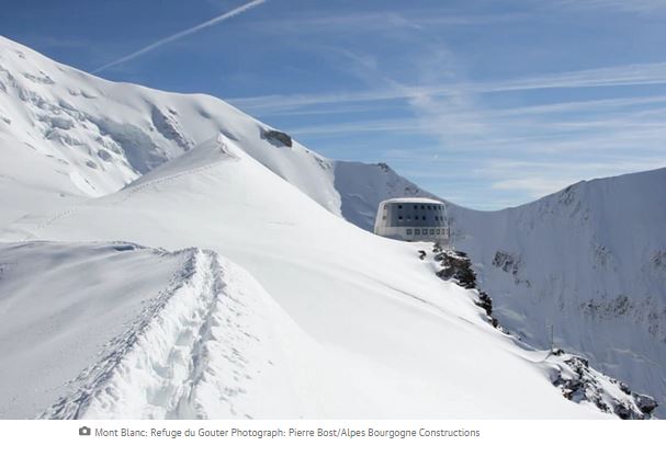
Lesson idea: map out where these resorts are located to create a spatial journal.
What is Where? Why There? Why Care?
Photo Gallery: New 7 Wonders vs. Ancient 7 Wonders

Concepts of Thinking: Spatial Significance, Geographic Perspective, Patterns and Trends
Lesson Idea: Have students create a spacial journal of all the Wonders of the World and make some observations. Ask the questions; What Is Where? Why There? and Why Care?
|
Killer whale with dolphin pod off Nova Scotia a rare sight
By Cassie Williams, CBC News Posted: Sep 25, 2015 12:33 PM AT

Concepts of Thinking: Interrelationships, Geographic Perspective,
Lesson idea:
Investigate What Is Where? Nova Scotia
Why There?
Why Care?
Why might this be of interest?
10 of the best ways to enjoy Copenhagen … on a
budget
The Danish capital’s reputation for
being expensive is not entirely deserved. With planning, there’s lots of fun to
be had on a shoestring (if a high-quality one) and even great places to stay
need not be out of reach

Go with the flow … a
Movia water bus approaches the Royal Danish Library stop on the Copenhagen
waterfront. Photograph: Alamy
Concepts of thinking:
Spatial significance, patterns and trends, geographic perspective
California’s Paso Robles wine route: top 10 guide
Paso Robles is the fastest growing wine
region in the US, with over 200 wineries, yet its tasting rooms are far less
busy – and its hotels and restaurants more affordable – than more famous Napa
and Sonoma

Concepts of thinking: Spatial significance, geographic perspective, patterns and trends, interrelationships
Lesson idea: Create a story map using ArcGIS Online
Villa San Juliette, Paso Robles


No comments:
Post a Comment