A Sustainable World
 A great teacher resource. Start the tour by using the Geography definition: What is Where? Why there? Why Care?
Please have a look at a new interactive map from Can Geo Education and Aga Khan Foundation examining world discrepancies in: Climate, Education, Health, and Gender.
There are several teacher friendly resources for your classes.
This would be very useful for all ages but works very well in grade 9 Geography and World Issues in the Ontario curriculum.
This is a great tool to help implement the Geographic Concepts of Thinking: Spatial Significance, Patterns and Trends, Interrelationships, and Geographic Perspective.
 Concepts of Thinking: Geographic Perspective, Interrelationships, Patterns and Trends, Spatial SignificanceInquiry: How might some Provinces proceed now that they are legally required to create their own carbon tax system if they do not want to follow the Federal Carbon Tax Plan? Why have some Provinces tried to make it hard for Canada to meets its Paris Accord targets by 2030?Action: Examine Canada's Paris Accord targets. Review the the strategies that Canada has committed to in achieving the targets. Conduct an issue analysis of the situation to better understand the values and beliefs of stakeholders involved in the situation. Create a spatial journal highlighting these stakeholders position. Make recommendations to the Provinces on how they should proceed to make sure the Paris Accord targets are meet by Canada and communicate this to the different levels of Government in a Story Map.
Please have a look at a new interactive map from Can Geo Education and Aga Khan Foundation examining world discrepancies in: Climate, Education, Health, and Gender.
There are several teacher friendly resources for your classes.
This would be very useful for all ages but works very well in grade 9 Geography and World Issues in the Ontario curriculum.
This is a great tool to help implement the Geographic Concepts of Thinking: Spatial Significance, Patterns and Trends, Interrelationships, and Geographic Perspective.
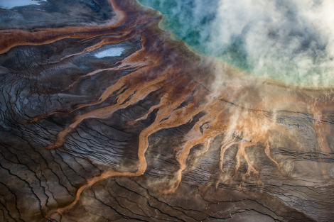
YELLOWSTONE SUPERVOLCANO MAY WAKE UP SOONER THAN WE THOUGHT NATIONAL GEOGRAPHIC 10/16/2017 ·
World must wake up to crackdown in Cambodia, says exiled opposition politician Oliver Holmes, South-east Asia correspondent


Concepts of Thinking: Interrelationships, Patterns and Trends, Geographic Perspective, Spatial Significance
Inquiry: How might this change policy impact countries, people in the region?
Activity: Create a spatial journal of the region that shows government type and demographics. Conduct an issue analysis to determine a possible course of action that could be taken that benefits the at risk. Communicate via story map.
The Catalan leader puts independence on hold for talks the Economist, Oct 10th 2017, BARCELONA
Concepts of Thinking: Geographic Perspective, Interrelationships
Inquiry: What might Catalans' independance look like?
Activity: Gather data on Spain and Catalan. Conduct an issue analysis to develop a strategy that may be acceptable by "most" stakeholders. Communicate a potential outcome of Catalans' independance via story map.
2.5 billion people lack access to basic sanitation
Concepts of Thinking: Interrelationships, Patterns and Trends, Geographic Perspective, Spatial Significance
Inquiry: How might this change policy impact countries, people in the region?
Activity: Create a spatial journal of the region that shows government type and demographics. Conduct an issue analysis to determine a possible course of action that could be taken that benefits the at risk. Communicate via story map.
The Catalan leader puts independence on hold for talks the Economist, Oct 10th 2017, BARCELONA


Controversial pesticides found in honey samples from six continents, Damian CarringtonEnvironment editor
 Concepts of Thinking: Interrelationship, Patterns and Trends, Spatial Significance
Inquiry: How might these pesticide samples impact people?
Activity: Gather data related to the study and create a spatial journal. Conduct an issue analysis to develop a plan of action. Communicate plan via story map.
Trump say Puetro Rico is an island surrounded by big water. Emily Shugerman New York
 Concepts of Thinking: Spatial Significance, Geographic Perspective
Inquiry: How might people know President Trump understands Spatial Significance?
Activity: Gather data from Presidents Trumps speeches and or actions that can be mapped to create a spatial journal. Review for any patterns and suggest corrections. Communicate via Story Map to the President.

Concepts of Thinking: Interrelationship, Patterns and Trends, Spatial Significance
Inquiry: How might these pesticide samples impact people?
Activity: Gather data related to the study and create a spatial journal. Conduct an issue analysis to develop a plan of action. Communicate plan via story map.
Trump say Puetro Rico is an island surrounded by big water. Emily Shugerman New York

Prescribed burns begin in Kananaskis Valley By Erika Stark, CBC News
 Concepts of Thinking: Geographic Perspective, Spatial Significance, Interrelationships, Patterns and Trends
Inquiry: How might the decision where to burn be made?
Activity: Gather relevant data and create a spatial journal. Conduct an issue analysis and determine where to burn and/or what other things might be done instead of prescribed burns. Communicate results via story map.

Global Gender Pay Gap Won't Close For 170 Years: Report By The Associated Press
 Concepts of Thinking: Patterns and Trends, Spatial Significance, Geographic Perspective
Inquiry: What might be necessary to create a situation where women and men earn the salary for the same work?
Activity: Create a spatial journal of the countries and the percentage gap they hold. Observe for patterns and trends and develop a strategy that might help improve the situation for women so that they can actually earn the same. Communicate the strategy via story map.

The Migration of Anatomically Modern Humans
 Concepts of Thinking; Spatial Significance, Patterns and Trends
Inquiry:Why might people have migrated? How might people have traveled? Why did people choose their routes? How might these routes relate to current migration routes?
Activity: Gather data on current migration (An other source). Create a proportional width arrow map indicating routes and numbers. Conduct an issue analysis and develop predictions to help meet the needs of future migrants. Communicate via story map.

Canadian, U.S., mayors oppose Great Lakes water diversion request CTV News
 Concepts of Thinking: Spatial Significance, Geographic Perspective
Inquiry: How might this diversion impact the Great Lakes ecosystem?
Activity: Conduct an issue analysis for the proposal. Create a spatial journal of the Great Lakes St. Lawrence Water Way. Create a story map to communicate whether or not the proposal should be excepted and communicate to an appropriate audience.

Hamilton will have 633K residents by 2026, says ward boundary study By Samantha Craggs, CBC News
 Concepts of Thinking: Spatial Significance, Patterns and Trends
Inquiry: How might this population growth impact the environment. What might be the best way for this population to be distributed in the area?
Activity: Create a spatial journal of population density of the Hamilton area. Evaluate the patterns and trends to make predictions to future growth. Add some environmental data and any other relevant information. Create a story map to explain the best population distribution that might impact the environment the least and communicate to the appropriate audience.

India’s Severe Drought Causing Havoc
 Concepts of Thinking: Spatial Significance, Patterns and Trends, Interrelationships, Geographic Perspective
Inquiry: How could these conditions have been predicted and/or prevented? How might India's drought impact other parts of the world?
Activity: Conduct an issue analysis of the problem. Create a spatial journal of the stakeholders, physical and climatic factors. Evaluate graphs and charts of climate. Develop a potential solution to the problem and communicate via story map to the appropriate audience.
 Concepts of Thinking: Spatial Significance, Patterns and Trends, Interrelationships, Geographic Perspective
California plans to unleash fly to crush ivy invasion By

Great Barrier Reef bleaching made 175 times likelier by human-caused climate change, say scientists
 Concepts of Thinking: Spatial Significance, Interrelationships, Patterns and Trends
Inquiry: How might be a plausible
Activity: Conduct an issue analysis and map out the data as well as the extent of the bleaching along the Reef. Add to the map human data i.e. distribution, industry etc. Create a story map to communicate your results
Why being a vegetarian traveller is often so hard to swallow Shahnaz Habib
 Concepts of Thinking: Spatial Significance, Patterns and Trends
Inquiry: How might a vegetarian traveller best meet their needs?
Activity: Research where vegetarianism is most common. Create a chloropleth map to communicate research findings. Add other travel information to map such as tourist attractions to determine the best places for travelers to visit and have quality vegetarian meals.
 Concepts of Thinking: Spatial Significance, Interrelationships, Patterns and Trends
Inquiry: How might be a plausible
Activity: Conduct an issue analysis and map out the data as well as the extent of the bleaching along the Reef. Add to the map human data i.e. distribution, industry etc. Create a story map to communicate your results
Why being a vegetarian traveller is often so hard to swallow Shahnaz Habib

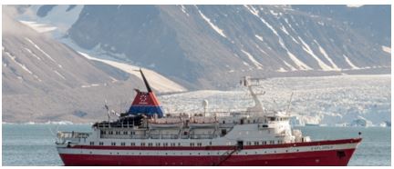
Arctic Cruises Are Extinction Tourism By Another Name Capt. Trevor Greene
 Concepts of Thinking: Geographic Perspective, Spatial Significance, Patterns and Trends, Interrelationship
Inquiry: How might tourist enjoy the Arctic without destroying it? What have been solutions in other similar situations? Could these solutions work for the the Arctic?
Activity: Map out the areas of greatest impact. Conduct an issue analysis and add to map the stakeholders. Determine a best fit solution and communicate to an appropriate audience via story map.
 Concepts of Thinking: Geographic Perspective, Spatial Significance, Patterns and Trends, Interrelationship
Brazil swine flu: H1N1 vaccinations to begin as virus kills 230 BBC
 Concepts of Thinking: Interrelationship, Patterns and Trends, Spatial Significance,
Inquiry: Where did this virus originate from?How might this virus be prevented, stopped from spreading? Where might this virus move to?
Activity: Create a map of the areas that are affected, past and present. Determine the spatial significance that contribute to the movement of the virus. Make predictions as to where the virus could move to. How might geographic perspective contribute to how the virus could be dealt with. Communicate result to an appropriate audience via story map.

Hunger Map 2015 World Food Programme
 Concepts of Thinking: Spatial Significance, Patterns and Trends, Geographic Perspective
Inquiry: In a world that is able to produce a surplus of food why are people still allowed to go hungry? How might a countries hunger rating change if only looking at domestic data (Canada as an example)?
Activity: Determine the stakeholder and conduct an issue analysis. Create flow map of the distribution of food. Add to the the flow of resource and aid countries around the world are involved in. Other data. Do any patterns appear? What might be some conclusions that can be made about food scarcity and Geographic Perspective and or Spatial significance? Communicate results to an appropriate audience via story map.

30 years after Chernobyl, UGA camera study reveals wildlife abundance in CEZ
 Concepts of Thinking: Spatial Significance, Interrelationships, Patterns and Trends
Inquiry: How have these animals been able to survive with the increased levels of radiation in their habitat? How likely is I that humans will be able to thrive with the increased radiation rates?
Activity: Map the Chernobyl nuclear power plant location. Determine level of contamination by creating buffers to show the range of contamination. Add population data and other relevant data to make predictions for how long before the land might be safe for people to go back to a "regular" routine in the area.

Diesel cars' emissions far higher on road than in lab, tests show Peter Walker and Graham Ruddick
 Concepts of Thinking: Spatial Significance, Patterns and Trends, Geographic Perspective
Inquiry: What might some of the consequences be to these increase levels? Where might these impacts be felt the most?
Activity: Create a map of the regions of the world that have diesel cars on the road. Add to the map air quality data and human patterns. Make some predictions of environmental impacts. Communicate to an appropriate audience via story map.
Governor wants to change, but not scrap, North Carolina law
By
 Activity: Conduct an issue analysis and map out the stakeholders. What are the patterns and trends of the analysis? Create a story map to communicate to the appropriate audience potential solution to the issue show how to bring about change.
Severe drought leaves millions relying on emergency aid
 Concepts of Thinking: Spatial Significance, Interrelationship, Patterns and Trends
Inquiry: What might be the spatial significance of this region that contribute to the drought?
Activity: Gather data on droughts of the region and create a map to help observe patterns and trends. Conduct an issue analysis and add stake holders to the map. Create a story map to communicate results.

Attawapiskat declares state of emergency over spate of suicide attempts By Kate Rutherford, CBC News
 Concepts of Thinking: Interrelationships, Patterns and Trends, Spatial Significance, Geographic Perspective
Inquiry: What might the factors be that are contributing to this community having an enormous suicide rate? What other communities might be facing a similar situation? How might this trend be turned around?
Activity: Create a map to determine the spatial significance of the area. Complete an issue analysis of the problem and and the stakeholders to the map. Communicate potential solution to the appropriate audience via story map.

Scientists to resurrect the aurochs, an extinct beast By

Farmland prices up 10% last year as property boom spreads to agriculture
CBC News Posted: Apr 11, 2016 8:47 AM ET
 Concepts of Thinking: Spatial Significance, Patterns and Trends, Geographic Perspective
Inquiry: Why might the farmland prices be going up. How does the farmland price increase compare to residential prices? Why might there be a difference?
Activity: Create a spatial journal of houses and farms. Add data such as land use to better discuss the difference. What might the future look like for both type of land use?

Maritime boat building 'boom' fuelled by lobster industry
By Paul Withers, CBC News
 Concepts of Thinking: Spatial Significance,
Geographic Perspective, Interrelationships
Concepts of Thinking: Spatial Significance,
Geographic Perspective, Interrelationships
Inquiry: Why has there been such an "boom" in building lobster boats? What might be the impacts of increased production of lobster boats?
Activity: Gather information and data on lobster "fishing". Conduct an issue analysis. Create a map of the extent of lobster fishing. Evaluate the human ans environmental impacts of increased lobster fishing to determine proper management of the resource. Communicate results to an appropriate audience via story map.

Massive deforestation found in Brazil’s Cerrado

Concepts of Thinking: Interrelationships, Patterns and Trends, Spatial Significance, Geographic Perspective
Inquiry: How might agriculture in the rain forest be sustainable?
Activity: Create a map showing the extent of rain forest deforestation over time. Conduct an issue analysis and add these groups to the map. Create a story map to communicate a solution to the problem.
Mekong megadrought erodes food security
 Concepts of Thinking: Spatial Significance, Interrelationships, Patterns and Trends
Inquiry: What might be the cause of the drought? Who might be most affected by the drought? What activities might be introduced to prevent such droughts happening in the future?
Activity: Create a spatial journal of the area /river basin indicating the different human activities. Show the extent/range of people who rely on the river basin for food. Identify locations where people may have to go to collect food in the future due to the drought. Communicate possible solutions to help alleviate the situation via story map.

Canada’s oilpatch suffers biggest drop in investment in almost 70 years, CAPP warns Yadullah Hussain | April 7, 2016 9:42 AM ET
 Concepts of Thinking: Patterns and Trends, Spatial Significance, Geographic Perspective, interrelationships
Inquiry: Why might Canada's Oil patch continue to suffer?
Activity: Conduct an issue analysis and map out the stakeholders. Make predictions on the future of Canada's oil industry and Canada's economy.

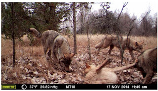
Ontario rescinds controversial proposals to ease wolf and coyote hunting regs in north
By Gord Ellis, CBC News
 Concepts of Thinking: Geographic Perspective, Patterns and Trends, Spatial Significance
Inquiry: How might the hunting of such animals impact human and natural systems.
Activity: Create an issue analysis of of the stakeholders. Create a map of the range of the wolf and coyote populations. Add layers such as cities, different animals, and vegetation etc. Determine what should happen next. Communicate results via a story map.

Turbulent battle as Golden, B.C., fights to save local river rafting industry
 Concepts of Thinking: Geographic Perspective, Interrelationship, Spatial Significance, Patterns and Trends
Inquiry: How might rafting company ensure that the increased access will not increase environmental impact?
Activity: Conduct an issue analysis and map out the the stakeholders and the site affected. Determine whether or not permission should be given and communicate to an appropriate audience via story map.

The Panama Papers: how the world’s rich and famous hide their money offshore Juliette Garside, Holly Wattand David Pegg
 Concepts of Thinking: Geographic Perspective, Spatial Significance, Patterns and Trends, Interrelationships

Inquiry: Why not allow equal access to such tax avoidance opportunities? How might such tax avoidance impact the local or national health of a country?
Activity: Create a proportional width arrow map to show where the taxes are leaving and where it is going to as well as the amount. Gather data on GDP, Life Expectancy, and Literacy to help determine how this tax evasion is impacting different parts of the world. Communicate your findings to an appropriate audience to help increase access to things like clean and safe drinking water.
It's Expensive To Be Poor 
 Concepts of Thinking: Geographic Perspective, Spatial Significance, Patterns and Trends
Inquiry: Who owns the water? How is it possible that a culture would make the poorest people pay the most for water? What could the wealthy people, corporations, and governments do to increase fair access to clean water for everyone?
Activity: Complete an issue analysis to determine the different values and beliefs associated with the issue.Map out areas (local, regional, or global) of areas where access to clean/safe drinking water is not readily available. Observe patterns that may appear. What could be done to alleviate the situation for people in need of clean/safe drinking water. Communicate to an appropriate audience.
Sea levels set to 'rise far more rapidly than expected Damian Carrington
 Antarctica’s snowfall was expected to keep the ice sheet in balance but it is less stable than previously thought. Photograph: Steve Mandel / Barcroft Media
Concepts of Thinking: Spatial Significance, Patterns and Trends
Inquiry: How might the expertise make these predictions? How should carbon emissions be decreased?
Activity: Collect and map carbon emissions data to determine where the majority of carbon is coming from. How might spatial significance impact carbon emissions? How can geographic perspective help influence carbon producers?

Concepts of Thinking: Geographic Perspective, Spatial Significance, Patterns and Trends
Inquiry: Who owns the water? How is it possible that a culture would make the poorest people pay the most for water? What could the wealthy people, corporations, and governments do to increase fair access to clean water for everyone?
Activity: Complete an issue analysis to determine the different values and beliefs associated with the issue.Map out areas (local, regional, or global) of areas where access to clean/safe drinking water is not readily available. Observe patterns that may appear. What could be done to alleviate the situation for people in need of clean/safe drinking water. Communicate to an appropriate audience.
Sea levels set to 'rise far more rapidly than expected Damian Carrington

Shoal Lake 40 First Nation Advocates Say More Money Needed For All-Weather Road By The Canadian Press
 Concepts of Thinking: Spatial Significance, Patterns and Trends, Interrelationships, Geographic Perspective
Inquiry: How could a community in Canada be under a boil water alert for so long? How could an all weather road help this community? Might there be other communities in similar situations?
Activity: Create a map showing the spatial significance of Shoal Lake 40.Gather information on other communities under a boil water advisory. Can any patterns be observed? What spatial significance is observed? How can this issue be addressed? Communicate results to and appropriate audience via story map.

‘Burnt Hot Dog’ sea cucumbers raise red flags for threatened global fisheries

Concepts of Thinking: Spatial Significance, Interrelationships
Inquiry: How does Spatial Significance contribute to the health of the Burnt Hot Dog? What might be done to maintain a healthy Burnt Hot Dog population?
Activity: Create a map Burnt Hot Dog populations around the world. Distinguish between healthy and none healthy populations. Observe any patterns that may appear. How might spacial significance impact the health of the Burnt Hot Dog?


No comments:
Post a Comment